By now you've probably seen the snowfall maps for Friday/Saturday. Depending on who you follow on social media and watch on TV, you've seen quite the spread of snow forecasts for Northeast Ohio. But who is right? How much snow will we really get?
Let's take this step-by-step and break things down.
Know your source
The first critical thing about what will happen Friday is to consider the source. What forecast model is being used? When you saw someone post snowfall numbers, what information did they provide with it? Was it just a map to simply say "look at all of the snow!"
On Monday the Global Forecast System (GFS) model was spitting out crazy high numbers for Friday night through Saturday. At one point, suggesting over 30 inches of snow for a good chunk of Western Pennsylvania.
That same day, a different computer forecast model (The European Model) went in the almost opposite direction. It was suggesting 30 inches of snow in Northern Indiana.
Look at the image below to see the difference between these two models. 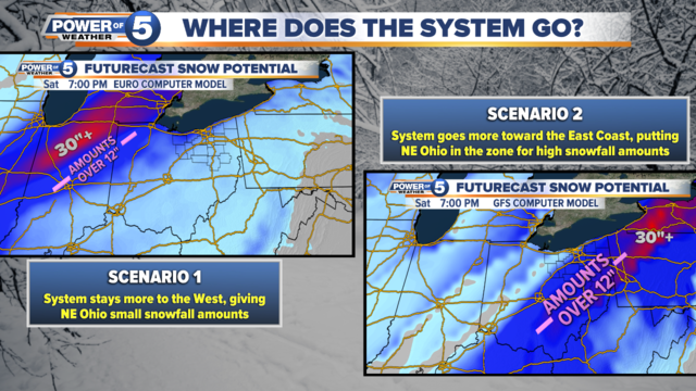
These are two of the main long-range forecast models used by meteorologists. But there are known problems with these models. For example, the GFS model tends to be more "over-the-top" with snowfall. Often times it will scream for high snow amounts days ahead of a storm, only to drop them the day of. On top of that, statistically speaking, the GFS model is usually more incorrect when compared to the European model.
This chart shows how well the European model does, versus the GFS:
The blue line being closer to the top indicates the Euro Model generally outperforms the GFS, meaning the Euro is more accurate.
Know the timing
Remember that the farther out we are from a storm, the more inaccurate the forecast models can be. Why? Because there are so many different variables in the atmosphere ahead of a major storm system.
This means too much can change — and suddenly — before the day of the storm actually arrives.
Think of it like a game of Plinko:

The takeaway here is to keep in mind the timing. If a storm is "days" away from hitting, this means there is still a lot of time for things to change. And drastically.
Meanwhile, if we are hours or a day away, forecast will typically be a lot more accurate.
What does all of this mean for the weekend?
As of Wednesday morning, the forecast models are starting to come into more agreement on what will happen. But there are still several variables at play which will lead to changes in the forecast.
Remember that we're still 48-60 hours away from the system moving through.
The system will move up from the Gulf Coast area, making a track toward the Northeast part of the country. However, it may still wobble along the broad track.

In general, it's looking more likely that we'll start with rain Friday morning. During the day, that rain will try to change over to snow. At some point, sleet and freezing rain will mix in. By Friday night, we should transition to all snow. That snow will continue through Saturday morning.
Right now, it's still hard to pin down exact snowfall amounts — despite what the models are suggesting. Why? Dynamics aloft in the atmosphere. One of those being warm air.
I am starting to grow more concerned about the potential for ice/sleet in Ohio. Warmer air may get drawn into the upper part of the atmosphere. This would melt the snow aloft, then turn it into sleet and freezing rain as it hits the surface.
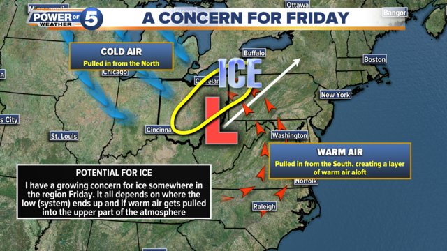
The forecast models are now starting to pick up on this a little bit. And if we get a couple hours of ice, that would greatly cut down on the snowfall amounts we'll get.
For example, if the model thinks it'll snow for six hours, but it snows for four and sleets for two, then snow amounts will change. It should be noted that the longer range forecast models (GFS and European) have a hard time picking up on ice potential and duration. That's because those models are not as finely detailed as the short-range models. Short-range models go 0-60 hours out from an event. That's where we are stating to move now.
Over the next day, meteorologists will get more data and higher resolution computer guidance. This will help improve and fine-tune the forecast. Which is why you should keep checking the forecast! It's going to change. And I'm willing to bet the final outcome will look a lot different than what the models were showing on Monday/Tuesday.
What to expect
Rain is looking likely Friday morning. Ice accumulations are looking possible Friday afternoon and early evening. Moderate to heavy snow possible Friday night into early Saturday. Snow tapers off through Saturday afternoon.
Key headlines
There are still a few things to keep in mind about our system for Friday:
Snow amounts
Still too early to call for sure. As of this morning, the GFS model is calling for a widespread 10-15" of snow.
The Euro says a widespread 5-8" of snow. Our in-house computer model is calling for a wide range: 3-14" across the viewing area, with the higher amounts West of I-77. (Note: I think that's because it's picking up on the ice potential from I-77 and East, cutting down on the snowfall).
I have a feeling we'll see a spread of snowfall amounts across the viewing area. We may also wind up with a band of ice over the area.
Bottom line
Friday afternoon into Saturday is going to be a mess across the area. We are going to get rain, we are going to get snow. Chances are increasing for ice. And it's possible that ice is significant somewhere in the region (we're talking ice amounts near 0.25". That would be trouble for power lines and trees).
Please keep eyes on the latest forecast. Remember that new forecast data comes in every 12 hours (on average), so it's important to check the morning forecast and the evening forecast.
Our Power of 5 Weather team will be tracking this system minute-by-minute and giving you updates. Follow us on air, online and on social media for the latest!
