


SUMMARY:
On and off showers and storms are likely as a cold front slides through the region. An upper-level disturbance will hang around into early next week and keep showers in the forecast. Some of the rain could become heavy on Monday resulting in hefty rainfall totals. Let's break down timing, severe potential and rainfall amounts below.

TIMING:
There will be dry periods between rounds of rain, but plan for a soggy few days. On and off rain/storms will are likely from Sunday until Wednesday! This is especially true during the afternoons and evenings with rain tapering at night. The heaviest rainfall is expected on Monday and in the Snowbelt. Rain rates could be 1-2 inches per hour! We will be monitoring any flooding that occurs over the next few days. The best chance for rain on Monday will be in our northern communities.
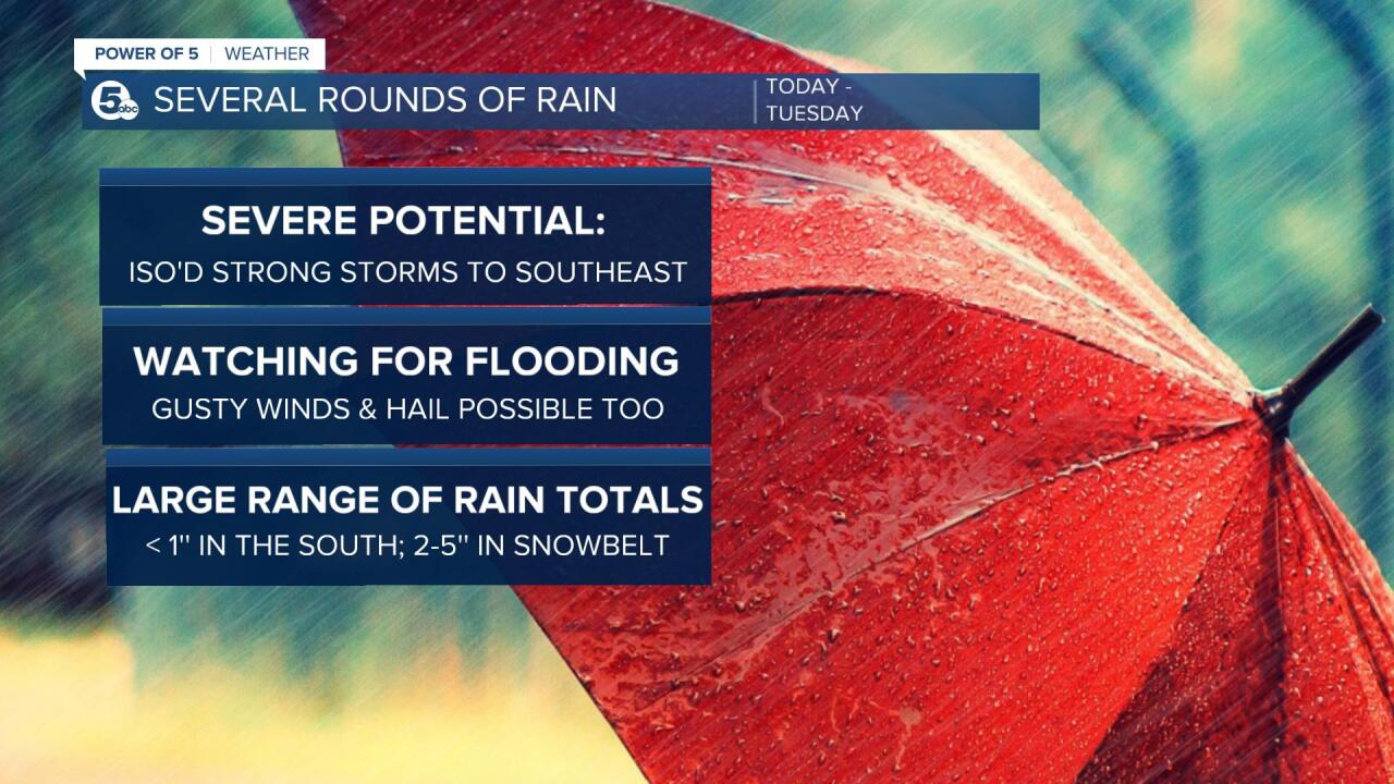
SEVERE POTENTIAL:
There is an isolated threat for strong or severe storms this afternoon/evening. This is most likely in our southeastern communities such as Stark, southern Summit, Carroll and Tuscarawas Counties. The area in green represents a marginal threat for severe storms. That is a level 1/5 and means 1 or 2 storms could contain gusty damaging winds and hail. There is a better chance for severe storms farther to the east in Pennsylvania and New Jersey.

Winds will be increasing on Sunday and continue to get stronger on Monday. Plan for a windy day with gusts over 35 mph. This will make it very choppy on Lake Erie. A small craft advisory goes into effect Sunday afternoon until Tuesday evening. Gale force winds may be possible during that time and resulting in large waves. The strongest waves are expected on Monday. Waterspouts and rip currents are also possible.

RAINFALL AMOUNTS/FLOODING:
A flood watch has not been issued by the National Weather Service as of Sunday morning, but that may change Sunday afternoon. If a watch is issued, it would likely only include a few counties such as Lake, Ashtabula and Geauga Counties. Bands of lake effect rain is likely on Monday and could produce repeated rounds of heavy rain. One band that developed on Sunday morning already dumped 1-3 inches of rain in this area. A flood advisory is in effect until 4:00 pm.
FLOOD ADVISORY issued for Lake and Ashtabula Counties until 4:00 pm. One batch of rain QUICKLY dropped 1-3 inches of rain. Minor flooding is possible in this area.
— Katie McGraw (@KatieMcGrawx) September 25, 2022
PLUS - this is day one! Rounds of heavy rain will likely affect this area in particular for days. pic.twitter.com/ahV7cjFIRc
When all is said and done, our northern and eastern communities could end up with several inches of rain. By the end of Tuesday 2-5'' will be likely in that area. Note how not everyone will be treated the same over the next few days. 0.50-1.00 inch of rain is possible around Cleveland to Sandusky and Akron. Totals drop even more south of Akron.
Check back for the latest information over the next several days.

Download the News 5 app for the latest weather updates:
Follow the News 5 Weather Team:
Mark Johnson: Facebook & Twitter
Trent Magill: Facebook & Twitter
Katie McGraw: Facebook & Twitter
