

The National Oceanic and Atmospheric Administration (NOAA) released its official 2025-26 winter weather outlook on Thursday, and the forecast for Northeast Ohio raises eyebrows, especially for snow lovers.
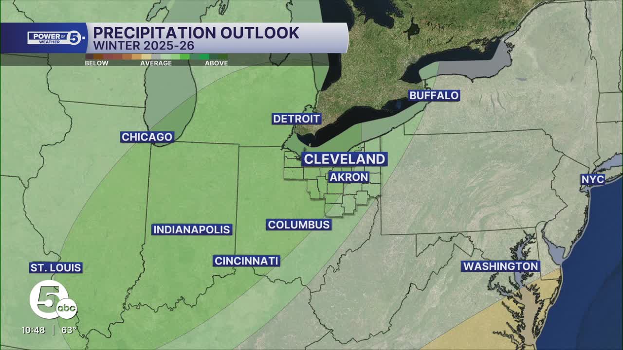
NOAA's official forecast calls for above-average precipitation in an area spanning from eastern Missouri and western Kentucky to Indiana and into much of Ohio. A higher probability of above-average precipitation lies west of Interstate 77 in Northeast Ohio. With more precipitation expected, does that automatically mean it will be a snowy winter?
Not so fast...

Just last winter, NOAA's forecast for winter 2024-25 called for slightly above-average precipitation. Cleveland Hopkins International Airport, the official National Weather Service reporting site for Cleveland, did receive above-average precipitation, nearly one inch above, in fact. Yet, it saw much below-average snowfall, almost 15 inches below normal. Precipitation does not always equate to snowfall, and several factors determine whether the surge in moisture results in more rain, snow, or both.
Some of these factors include sea surface temperatures in the Pacific Ocean, which are better known as El Niño and La Niña. Warmer-than-average water temperatures along the equatorial Pacific are known as an El Niño; the opposite (colder) is known as a La Niña. The water temperatures impact pressure patterns all around the world, and as a result, the track that winter storms take when approaching the Great Lakes.
Last winter was actually neither El Niño nor La Niña; it was basically a "la nada" without either. The lack of a prominent El Niño or La Niña prevented any significant storms from tracking in a particular way to drop major snowfall across the area.
This winter, a weak La Niña is expected to develop for December and January before beginning to fade to another "la nada" for February and beyond. The introduction of a La Niña could unlock a more common storm track that could bring snowier winter storms.
Temperature-wise, an average winter is most likely, according to NOAA's official winter forecast. Cold snaps and warm-ups can still occur, but when averaged out over the course of December, January, and February, they would have a higher chance to equal out to an average winter temperature-wise. Last winter's forecast called for slightly above-average temperatures, yet the opposite occurred. Temperatures were several degrees below average from December to February, thanks to several visits by the polar vortex.

La Niña is one of many factors in producing a winter forecast, and stay tuned as the Power of 5 team continues to crunch the data and formulate this winter's forecast for Northeast Ohio. With NOAA's forecast in the books and factors like La Nina, Siberian snow cover, and the polar vortex starting to take shape this fall, do not expect a carbon copy winter forecast this year.
Want the latest Power of 5 weather team updates wherever you go? Download the News 5 App free now: Apple|Android
Click here to view our interactive radar.
Follow the News 5 Weather Team:
Trent Magill: Facebook & Twitter
Katie McGraw: Facebook & Twitter
Phil Sakal: Facebook & Twitter
Allan Nosoff: Facebook & Twitter
