

Hold on to your hats (literally) as we end this week, as it is going to be a bumpy ride!
A strong cold front will be moving across the country in the coming days, and out ahead of it, warmer air and windy conditions are increasing.

Winds out of the south and southwest will pump in more above-average warmth into Northeast Ohio during the day Thursday. High temperatures will be in the 50s, but unfortunately, the winds will not make for much enjoyment of the warmth.

Winds will be on the increase during the morning rush, with gusts of 20 to 30 mph a possibility. The higher gusts will be in our western communities.

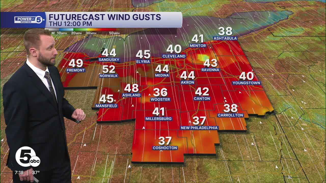
As we head into the late morning and throughout the entire afternoon, the winds will continue to strengthen. Wind gusts for most of the region will be in the 40 to 50 mph range.


The highest winds will especially be in our western communities during the afternoon once again. As the cold front begins to near the region, rain chances will begin to increase as well. During the early afternoon, rain chances will be minimal.

But as the afternoon continues, the rain chances will begin to increase from west to east.

During the evening, the front will begin to move through the region. This will be the strongest portion of the rain, which will be heavy, and even thunder will be possible.

Anticipate the front to move through the Cleveland, Akron-Canton metros between 7:30 and 8:30 p.m. Thursday. Winds will begin to taper somewhat behind the front, but still expect a very windy Thursday night and Friday as colder air filters in.

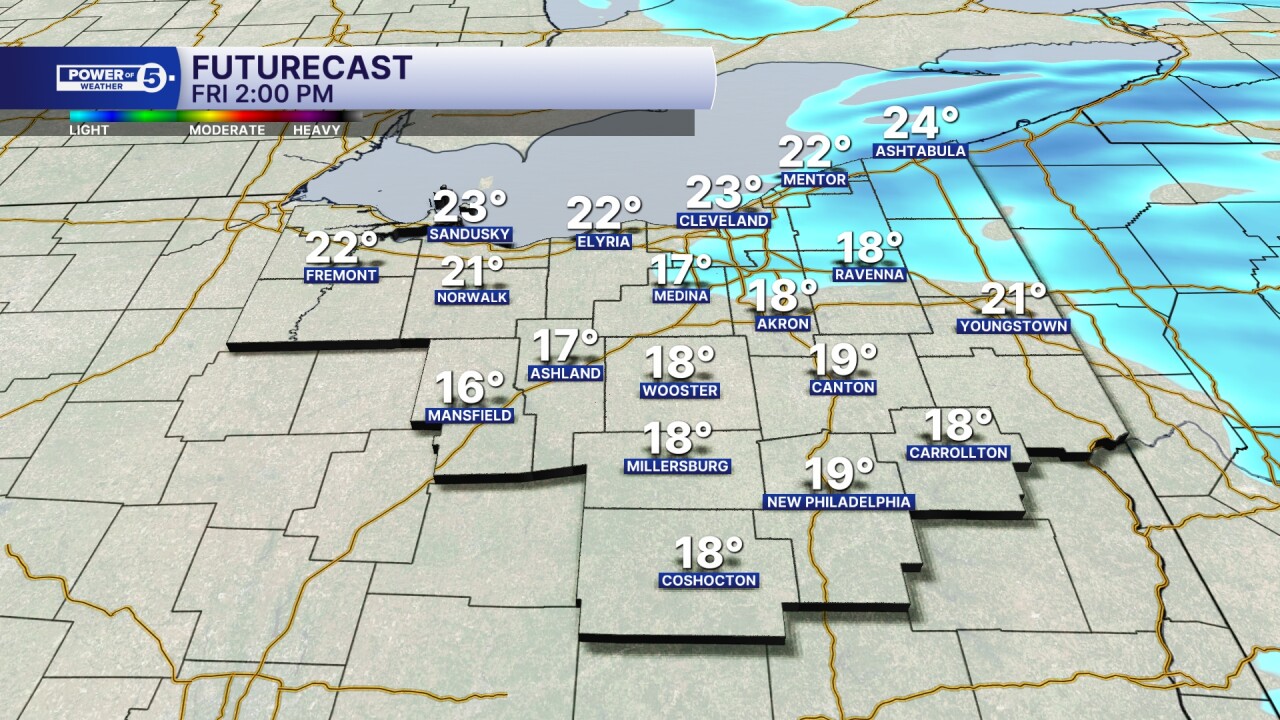
The colder air will begin to make an appearance before we hit midnight on Friday, and it will continue to get colder throughout the wee hours of Friday morning.

So, all of the rain and liquid that fell Thursday evening will have a chance to freeze during the morning on Friday, along with snow chances. You'll need to plan on extra time to get anywhere on Friday morning, as temperatures will be below freezing to begin the day and will get colder as the day continues. Wind chills will be dangerously cold, with many areas in the Single Digits by Friday morning.

Below-zero wind chills will also be possible Friday morning.

Wind chills remain in the single digits into the afternoon hours, along with more snow developing.

By the late morning into the afternoon, lake effect snow showers will begin to arrive across the snowbelt region, and will bring some additional accumulation from Cleveland northeast towards Ashtabula.
By the late morning into the afternoon, lake effect snow showers will begin to arrive across the snowbelt region, and will bring some additional accumulation from Cleveland northeast towards Ashtabula. A general inch or less is expected for most areas, along with slick spots, but in the snowbelt, a few inches of snow will be possible by the end of Friday evening.

Temperatures will be well above average on Thursday, then fall once again on Friday. They will then rise to just above seasonal norms once again on Saturday, with highs in the 40s.

Want the latest Power of 5 weather team updates wherever you go? Download the News 5 App free now: Apple|Android
Click here to view our interactive radar.
Follow the News 5 Weather Team:
Trent Magill: Facebook & Twitter
Katie McGraw: Facebook & Twitter
Phil Sakal: Facebook & Twitter
Allan Nosoff: Facebook & Twitter
