


CLEVELAND — The powerful storm system that produced big a tornado outbreak overnight in other states will bring us the threat for a few strong to severe storms the rest of this morning through early afternoon. Widespread strong winds and a big temperature crash are also coming.
Watches, Warnings and Advisories
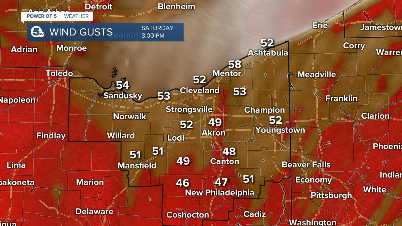
A High Wind Warning is in effect until 7 p.m. for the following counties: Erie, Huron, Lorain, Richland, Ashland, Cuyahoga, Lake and Ashtabula. Wind gusts up to 60 mph are expected.
A Wind Advisory is in effect from noon until 7 p.m. for the rest of the News 5 viewing area. Wind gusts up to 55 mph are expected.
A Gale Warning is also in effect from 10 a.m. until 10 p.m. for gusts near 50 to 55 mph and waves as high as 10 to 15 feet across Lake Erie.
A Flood Advisory has been issued for the following counties until 3:45 p.m.: Ashland, Medina, Wayne, Richland Portage and Summit. Minor flooding could occur in low-lying or poor drainage areas due to rain in those counties.
Power outages
Power in parts of Cleveland are out due to high winds. According to Cleveland Public Power, there is an outage in the area of Miles Avenue to Woodland Avenue from East 110th Street to East 160th Street. Other areas include Carnegie Avenue to Woodland Avenue from East 21st Street to East 108th Street. Cleveland Public Power said that power has been restored to the area of Detroit Avenue from West 45th Street to West 85th Street.
FirstEnergy has reported outages across multiple counties across Northeast Ohio.
Customers without power by county:
- Ashland- 2,159
- Ashtabula — 11,912
- Cuyahoga County — 19,168
- Erie County — 991
- Geauga County — 3,767
- Lake County — 3,831
- Lorain County — 1,598
- Medina County — 676
- Portage — 3,821
- Richland County — 1,681
- Summit — 4,811
Click here for links to view power outages in your area.
Road closures
TRAFFIC ALERT: SR 306 is closed between U.S. 322 and SR 87. Please use an alternate route and check OHGO for updates. pic.twitter.com/zGlnX5Gy1T
— ODOT Cleveland (@ODOT_Cleveland) December 11, 2021
Canceled events
High winds and power outages have prompted some event closures.
ALERT: Because we are without power at Gordan Square Arcade, the venue for today's COVID-19 vaccination clinic, we have ended the clinic two hours early. Please re-schedule at https://t.co/HqJxRstyOP or 216-664-2222. Thx! @CityofCleveland #DetroitShoreway pic.twitter.com/nJbozZFbIK
— Cleveland Department of Public Health (@CleDPH) December 11, 2021
What to expect
Potential for tree and powerline damage exists today everywhere, especially in High Wind Warning areas.

Gusty winds could blow around unsecured objects.
Rain will continue to push in today as temperatures warm into the upper 50s and lower 60s. Winds will gusts above 30 mph at times too.
Our high wind threat comes in two waves today. Strong storms this morning will have heavy rain, occasional lightning and an even higher threat for wind damage. Winds are likely gusting to 50 mph while the storms are rolling through. Once the cold front moves by early afternoon and the storms fade out, the second wave of strong winds will arrive behind the front.
Strong winds will continue through Saturday evening with wind gusts above 50 mph, especially near the lake shore. Non-thunderstorm wind damage and power outages will be a concern.
Temperatures will tumble during the afternoon, out of the 60s and into the 30s by sunset. That cold air blowing over Lake Erie could give us a few snow showers this evening into tonight.
Thankfully, the winds relax heading into Sunday with some sun in the forecast for the Browns game.
Want the latest Power of 5 weather team updates wherever you go? Download the News 5 App free now: Apple|Android
Download the StormShield app for weather alerts on your iOS and Android device: Apple|Android
Click here to view our interactive radar.
Read and watch the latest Power of 5 forecast here.
Follow the News 5 Weather Team:
Mark Johnson: Facebook & Twitter
Remeisha Shade: Facebook & Twitter
