Weather

Actions

FLASH FLOOD WARNINGS issued for Summit, Portage, and Tuscarawas counties

Flood watch issued for several communities across Northeast Ohio for Friday
slot0.jpg
Posted
and last updated

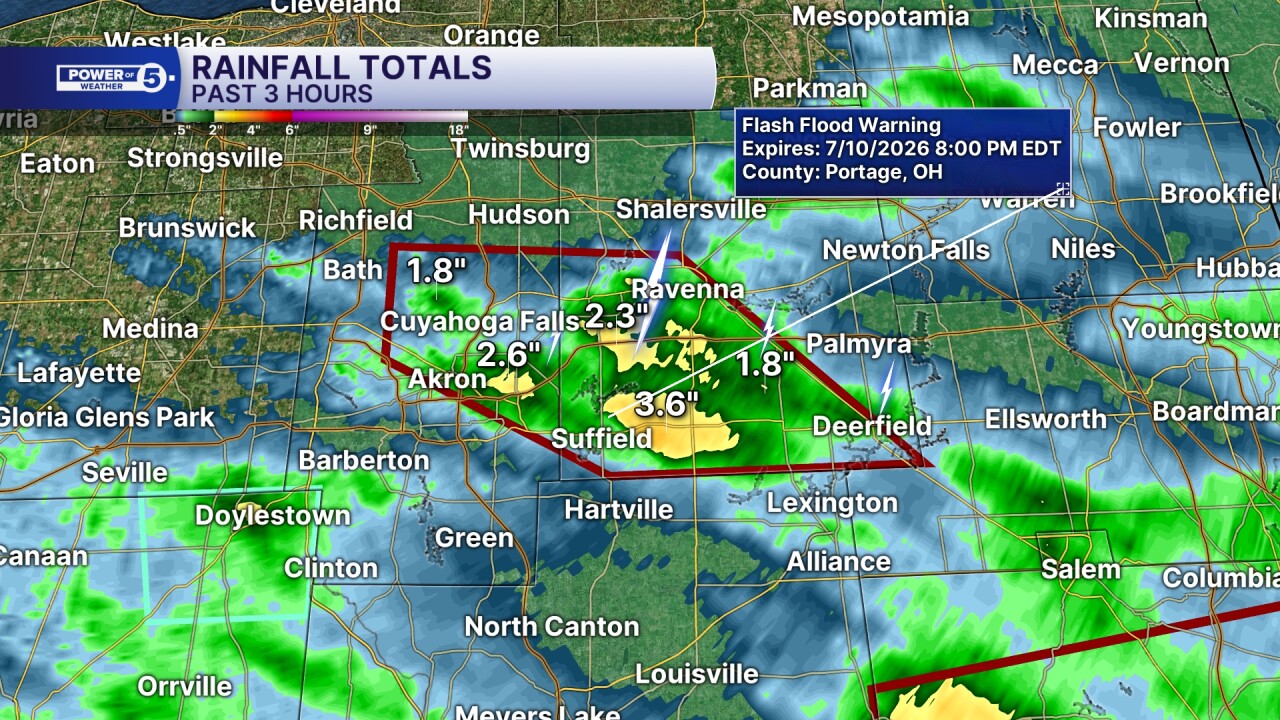
CLEVELAND — Hit-and-miss storms with torrential rainfall are expected for the next few hours, especially for communities away from the lakeshore. As a front slides through from north to south, rain chances will gradually push south by tonight, but for the next few hours, downpours and lightning will be possible. These are scattered storms, so some folks will be hit with incredibly heavy rain and slow-moving storms that could lead to localized flooding and flash flooding due to the excessive rainfall.

A flood watch has been issued for the southern two-thirds of our viewing area, including Summit, Portage, Ashland, Holmes, Richland, Stark, Wayne, and Trumbull counties. The flood watch is in effect until 10 p.m.

slot1.jpg

FLASH FLOOD WARNINGS have been issued for...

  • SUMMIT & PORTAGE COUNTIES: The warning is in effect until 8 pm. Around 5:15 p.m. on Friday, the flood advisories were upgraded to warnings after thunderstorms dropped 1-3 inches of rain across the area. Additional rainfall of 1 to 1.5 inches is possible. Some locations that will experience flash flooding include... Akron, Ravenna, Cuyahoga Falls, Kent, Hudson, Tallmadge, Mogadore, Stow, Brimfield, Fairlawn, Randolph, Munroe Falls, Lakemore, Atwater, Edinburg, Silver Lake, Deerfield, Brady Lake and Montrose-Ghent.
  • TUSCARAWAS COUNTY until 8 p.m. Thunderstorms are producing heavy rain across the warned area. Between 1.5 and 2.5 inches of rain have fallen. The expected rainfall rate is 2 to 3 inches in 1 hour. Additional rainfall amounts up to 1 inch are possible in the warned area. Flash flooding is ongoing or expected to begin shortly. Flash flooding of small creeks and streams, urban areas, highways, streets, and underpasses, as well as other poor drainage and low-lying areas. Some locations that will experience flash flooding include Uhrichsville, Dennison, Gnadenhutten, Tuscarawas, Port Washington, Stillwater, Deersville, and Tappan Lake.
slot2.jpg
sloT3.jpg

Flood advisories have been issued for a few communities:

  • WAYNE COUNTY: Until 8 pm. Flooding caused by excessive rainfall is expected. Minor flooding is ongoing or expected to begin shortly in the advisory area. Between 1 and 1.5 inches of rain has fallen, with another half inch to an inch expected. Some locations that will experience flooding include Rittman, Doylestown, Norton, and Marshallville.
1

Showers and thunderstorms will continue until this evening, with rainfall rates that may reach 2 to 3 inches per hour at times with slow-moving storms. Some communities could also be impacted by repeated rounds of heavy rain. Excessive runoff may result in flooding of rivers, creeks, streams, and other low-lying and flood-prone locations.
*Remember: if and when a flash flood warning is issued where you live, take it very seriously. Do not drive unless you need to, and NEVER drive through flooded roads.*

Want the latest Power of 5 weather team updates wherever you go? Download the News 5 App free now: Apple|Android

Click here to view our interactive radar.

Follow the News 5 Weather Team:

Trent Magill: Facebook & Twitter
Katie McGraw: Facebook & Twitter
Phil Sakal: Facebook & Twitter
Allan Nosoff: Facebook & Twitter