


CLEVELAND — Skies are clearing out nicely behind the exiting showers and thunderstorms, which are now in Western Pennsylvania. A trough of low pressure will move thru the area tonight ushering in below normal temperatures for the next few days. Temperatures tonight will drop down to near 50 degrees by sunrise. Grab the sweaters.
Temperatures Tuesday will be MUCH cooler with highs in the lower 60s. But, at least we'll see sunshine all day.
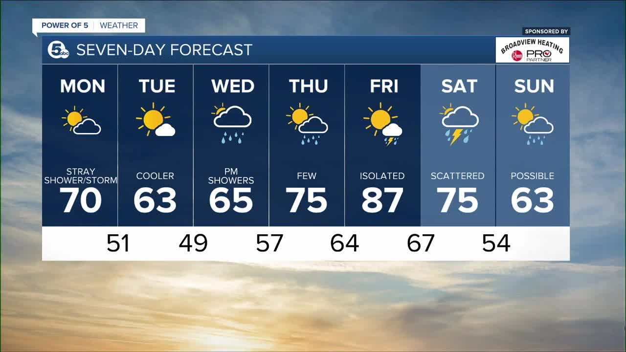
Plan on 60-degrees weather through midweek with upper 70s Thursday and near 90º by Friday!
It's a short lived rebound though... another cold front, more storms and cooler (more seasonable) air settles in for the weekend.
FORECAST HEADLINES
- Clearing & cooler tonight
- Cooler 60s for Tuesday & Wednesday
- A warm front arrives for Thursday
- Thursday's highs near 77 with a few showers
- Big heat coming back late week with highs near 90
DETAILED FORECAST:
Monday Night: Clearing & cooler.| Low: 51º
Tuesday: Coolest day of the week. Dry.| High: 63º
Wednesday: Scattered PM Showers. | High: 65º
Thursday: Few PM Showers. | High: 77º
Friday: Sizzling with temps soaring. Isolated PM storms. Windy.| High: 88º
Saturday: Scattered thundershowers. | High: 75º
Sunday: Partly cloudy. Cooler. | High: 62º
Download the News 5 app for the latest weather updates:
Follow the News 5 Weather Team:
Mark Johnson: Facebook & Twitter
Trent Magill: Facebook & Twitter
Remeisha Shade: Facebook & Twitter
Katie McGraw: Facebook & Twitter
