


CLEVELAND — MONDAY, JULY 28 WEATHER UPDATE: An upper-level disturbance is affecting Northeast Ohio this evening and helping to fire off scattered storms. These storms are packing a punch with gusty, potentially damaging winds, frequent lightning, and torrential rain that is causing flooding in our northwestern communities.
Watch the latest from Meteorologist Katie McGraw:
ACTIVE ALERTS:
- A Flash Flood Warning has been issued for Erie, Huron, Ottawa, and Sandusky counties until 10 p.m. after 1-3 inches of rain have fallen in a very short time. Additional rainfall of 0.5 to 2 inches of rain are possible in the area, resulting in flash flooding. TURN AROUND DO NOT DROWN! Take the flash flood warning seriously. If you do not have to travel for the next few hours, don't. Most flood deaths happen in vehicles.
- A Flood Advisory has been issued for Lorain County until 9 pm after 0.5- 1.5 inches of rain have fallen in the last hour. Another 0.5-1 inch of rain is possible in the advisory. Ponding of water in urban areas is expected.
CLICK HERE to see the list of severe weather watches, warnings, and other weather alerts from the NWS that are currently active in our area.
Scattered storms are *most* likely in our western communities for the next few hours. Storms are expected to fade shortly after sunset on Monday. Listen for thunder and have a plan in place to seek shelter. Remember: "When thunder roars, get indoors!"
EXPIRED ALERTS:
A Tornado Warning was in effect for Medina, Summit and Wayne counties but has since expired. A Severe Thunderstorm Warning for Erie and Lorain counties has also expired.
A Severe Thunderstorm Warning was in effect for Stark County until 8:15 p.m. and until 8:45 p.m. for Tuscarawas, Carroll and Columbiana counties. The advisory has expired.
Radar
View the current Power of 5 Weather Radar below:
Power outages
Visit our Power Outage page to find links to see current power outages in Northeast Ohio and to report a power outage.
Traffic impacts
View our News 5 Traffic Map to see any road closures or delays due to the weather or crashes from the weather.
Send us photos, videos and reports of the weather
Please stay safe! Do not put yourself in danger to get a photo or video of severe weather. You can email photos and short videos to 5pix@wews.com and email storm reports and information to newsdesk@wews.com.
You can also submit information to us via the form on our Contact Us page here. For files larger than 10MB, please utilize a file-sharing service like DropBox or WeTransfer.
Want the latest Power of 5 weather team updates wherever you go? Download the News 5 App free now: Apple|Android
Download the StormShield app for weather alerts on your iOS and Android device: Apple|Android
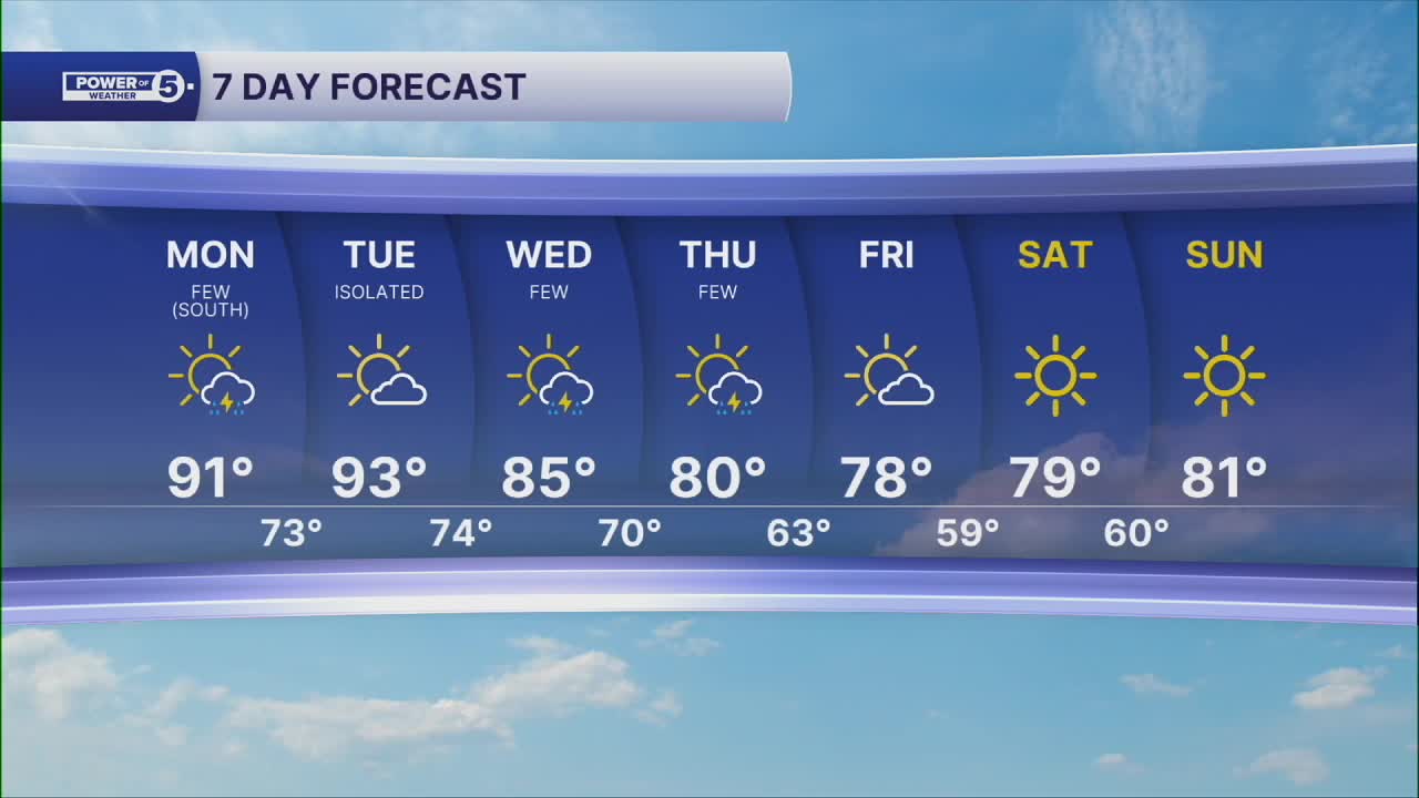
Read and watch the latest Power of 5 forecast here.
Follow the News 5 Weather Team:
Trent Magill: Facebook & Twitter
Katie McGraw: Facebook & Twitter
Phil Sakal: Facebook & Twitter
