


This spring so far has been filled with wild weather swings, temperature roller coasters, and more severe weather than usual.
While severe storms and near-record temperatures often top the headlines, the processes that occur in the middle of the drastic weather swings affect more than you think.
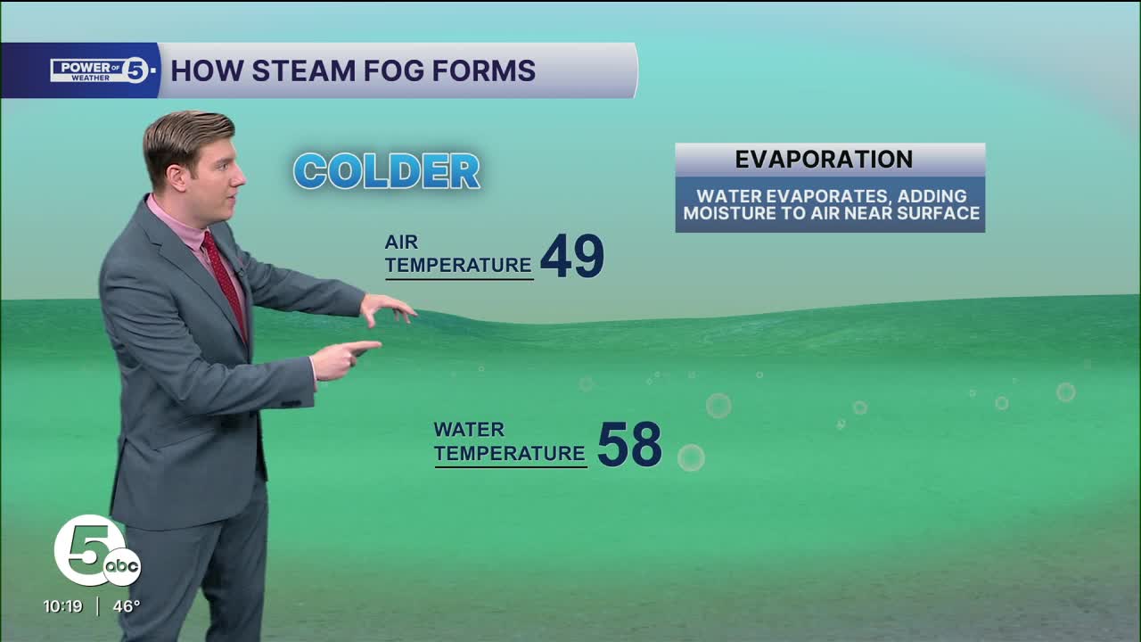
Dense fog has been a part of not just this weekend's weather, but last weekend's too — fog that one of our News 5 viewers, Tricia in Lake County, said, "looked like steam."
The drastic drops from near-record, summer-like warmth to winter-like chill help create fog, especially near the lake.
As the air temperature drops, it drops below the water temperature of Lake Erie. When the water temperature is warmer than the air, it lets moisture escape the lake into the colder air right above it, where it then gets trapped.
As that warmer, moist air gets trapped right above the water at ground level, it becomes steam fog.
The changing conditions, from warm to cold, let you see lots of fog, especially near the lake. The changing conditions, from cold to warm, allow you to see a different phenomenon.
As our temperature roller coaster has seemingly not stopped, there is another big warmup in the forecast for Monday and early Tuesday. Not every warmup is the same, however, which is why this particular setup is prime for tropospheric ducting.
Tropo-what?! Tropospheric ducting, or tropo for short, is a phenomenon where TV and radio signals can be received far away from their intended coverage area because of certain weather conditions.
What kind of weather conditions are expected, and why will Northeast Ohioans be able to receive Canadian stations with ease overnight?
Instead of the temperature clash of the water and the air, there is a different kind of temperature clash happening above us, known as an inversion. Usually, the air gets colder the higher up you go in altitude.
With a warm surge incoming Monday, the warmth arrives faster above ground than it does at ground level. That means the air above us is warmer (which is also denser), causing any TV or radio waves to bend back to the ground instead of freely escaping into space. This process repeats for dozens, if not hundreds of miles, wherever the inversion is present, which is expected to be in place for much of Northern Ohio, as well as all the way to Michigan and eastern Indiana.
Want to learn more about this process? Check this out: How weather impacts what you see and hear.

Based on the current forecast, and looking at various soundings and atmospheric profiles, the areas in red have the best opportunity to see and hear stations normally not receivable. The best time is likely just before sunrise, between 5 and 7 a.m., and quickly dissipating before noon.
If you live lakeside, scan your TV or tune the dial on your FM radio in the morning, and receive a bunch of stations from Detroit, Windsor, Chatham, and London, with the potential for receiving stations as far away as Upper Michigan and eastern Indiana.
The two arrows drawn on top of the graphic show the most likely "ducts," which are paths for signals to easily move across for the longest distances. For coastal areas, the Lake Erie connection to various cities north and west of Cleveland is most likely. For inland areas, especially south of the Turnpike, stations to western Ohio and eastern Indiana are most likely, with a smaller chance of stations to Southern and Central Ohio.
Have any questions on how to successfully receive these stations? Comment on my Facebook post about this phenomenon, and I'll be sure to answer.

Want the latest Power of 5 weather team updates wherever you go? Download the News 5 App free now: Apple|Android
Click here to view our interactive radar.
Follow the News 5 Weather Team:
Trent Magill: Facebook & Twitter
Katie McGraw: Facebook & Twitter
Phil Sakal: Facebook & Twitter
Allan Nosoff: Facebook & Twitter
