


Sunday Morning Update:
A few morning showers rolled through NE Ohio overnight and spotty showers are fading this morning. After a brief lull in the activity, hit or miss/scattered showers and storms are expected to develop during Sunday afternoon and some storms could be strong or severe.
As of Sunday morning, the Storm Prediction Center has placed the southern half of the Power of 5 viewing area at a marginal risk for severe weather on Sunday. This is a level 1/5 and it includes Akron, Wooster, Canton, Mansfield, Shelby, Green and New Philadelphia. If storms become strong or severe, the main threat will be damaging winds. Isolated tornadoes and hail are not off the table, but the threat is lower. The best chance for stronger storms on Sunday will be in the mid to late afternoon and throughout the evening. Not everyone is expected to be impacted by these storms because they will be hit or miss. Storms will fade after sunset with a few showers possibly overnight.

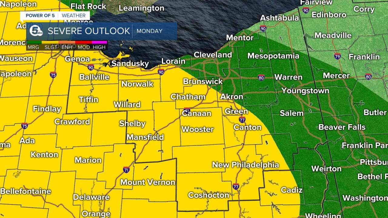
Most of Monday will be dry, but there is another chance for severe weather on Monday night and into Tuesday morning. As of Sunday morning, The Storm Prediction Center has issued a severe weather risk for the entire viewing area. There is a slight risk posted for about half of the area, mainly to the west. This is a 2/5 risk level and means that scattered severe storms are expected in the yellow area. The slight risk includes Norwalk, western Lorain County, southern Summit County, Sandusky, Wooster, Shelby, Mansfield, and Canton. The area in green is a marginal risk for severe weather and is a level 1/5 and includes Cleveland, Akron and Mentor. This shows there is a better chance to experience severe weather to the west and south of Cleveland on Monday. While all modes of severe weather are possible on Monday, the main threat will be damaging wind gusts. Large hail, isolated tornadoes, and heavy rain that could lead to flooding will also be possible.
Tomorrow's severe potential is not a slam dunk forecast. There is quite of bit of uncertainty at this time with the way the next system evolves and the exact track of powerful storms. It could bring widespread strong to severe storms for our area or a swing and a miss for our area. I suggest checking in with the Power of 5 Weather Team Sunday and Monday for the latest updates to the forecast. We will be monitoring conditions over the next two days. Stay weather aware and safe!
Want the latest Power of 5 weather team updates wherever you go? Download the News 5 App free now: Apple|Android
Download the StormShield app for weather alerts on your iOS and Android device: Apple|Android
Click here to view our interactive radar.
Read and watch the latest Power of 5 forecast here.
Follow the News 5 Weather Team:
Mark Johnson: Facebook & Twitter
Remeisha Shade: Facebook & Twitter
