

CLEVELAND — Northeast Ohio is one of the few places on Earth that receives significant lake effect snow.
If you have lived in Northeast Ohio or Greater Cleveland for some time, you are likely familiar with lake effect snow, but do you know WHY it actually happens?
There are three main factors meteorologists look for to produce the phenomenon of lake effect snow.
- A large area of open water of at least 100 km known as a "fetch"
- Water temperatures that are warmer than the air moving over it. As a rule, the difference must be 13 degrees Celsius (or colder) between the water temperature and the air temperature around 5,000 feet above the water
- Wind directions will dictate the location of the snowfall, as well as its intensity, and wind speeds need to be between 10 to 45 mph to have enough moisture to create snow bands.
The distance wind travels over the lake is known as the "fetch”.
To get lake effect snow, you need a fetch of at least 62 miles or 100 km.
The longer the fetch, the more moisture available for lake effect snow.
This is why lake effect snow (and rain) is the most common across the Great Lakes.
Many of the Great Lakes are long and narrow, with a long fetch, which is ideal for the development of heavy bands of lake effect snow.
Only a slight shift in wind direction can drastically alter the location and intensity of the snow.
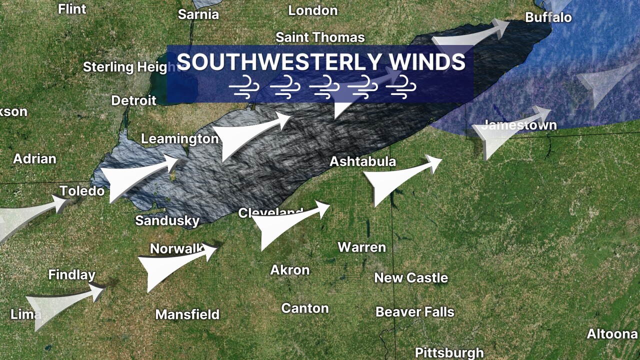
For example, a southwest wind blowing over Lake Erie will keep the snow out of NEO and push it toward Buffalo, but it is a very long fetch and can result in extreme snowfall totals.
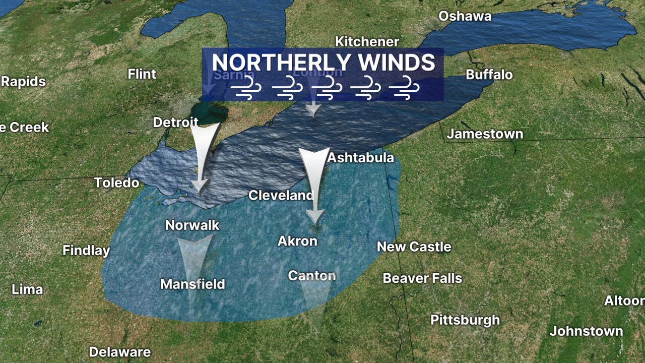
Meanwhile, a northerly wind typically brings snow farther west and farther inland, but the intensity is significantly lower due to the shorter fetch across Lake Erie.
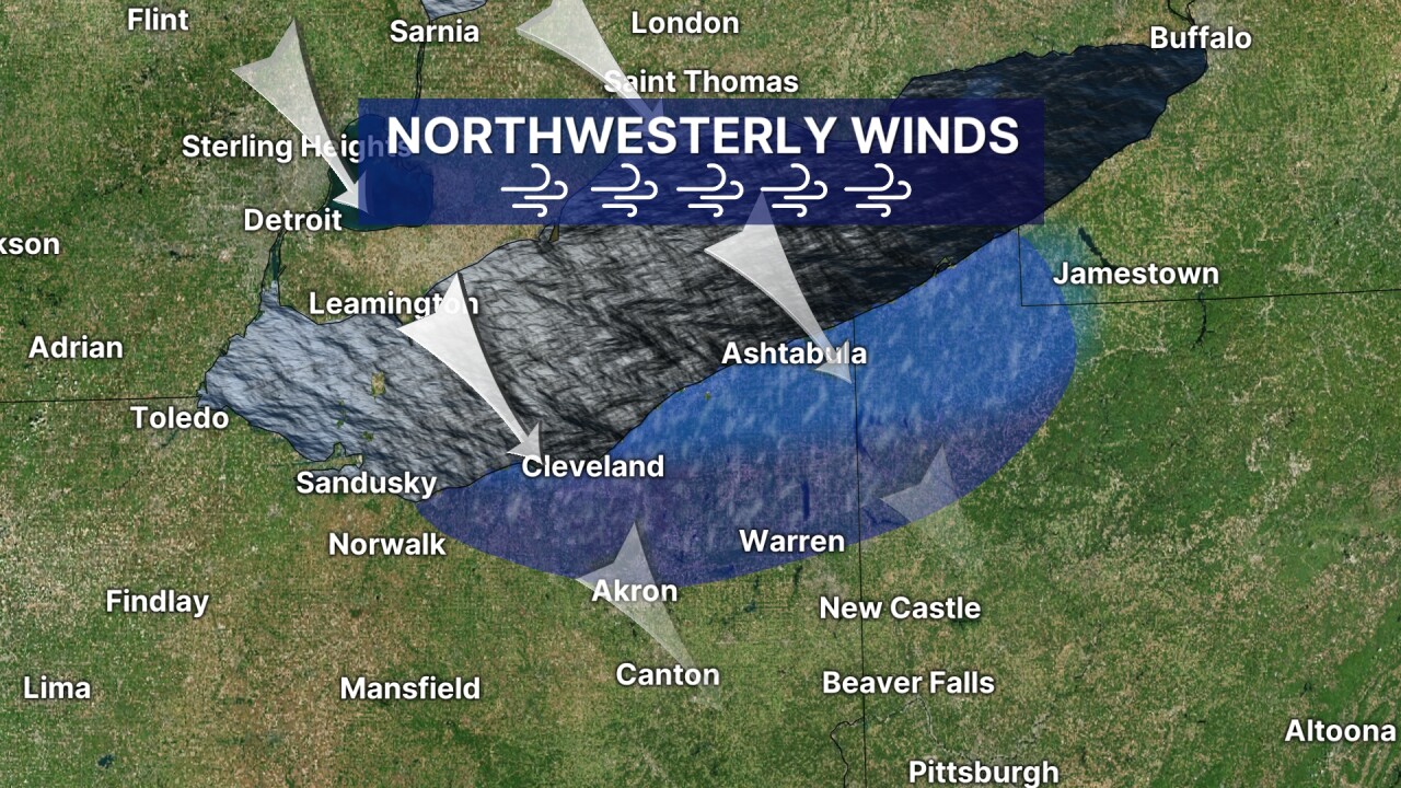
A northwest wind will typically bring a band or bands of lake effect snow to the primary and secondary snowbelts.
And a westerly wind can pummel the primary snow belt with intense snow. Snowfall rates from westerly winds can reach 2 inches per hour!

This is why there are HUGE ranges in snowfall totals during lake effect snow events
Remember last November?
Saybrook in Ashtabula County picked up over 63 inches of snow in just one lake effect event.
Meanwhile, at Cleveland Hopkins airport... around 31 inches of snow fell...but for the entire 2024-2025 winter season!
So the next time someone asks you why east-siders see so much more snow than west-siders, you can blame it on the fetch!
Want the latest Power of 5 weather team updates wherever you go? Download the News 5 App free now: Apple|Android
Click here to view our interactive radar.
Follow the News 5 Weather Team:
Trent Magill: Facebook & Twitter
Katie McGraw: Facebook & Twitter
Phil Sakal: Facebook & Twitter
Allan Nosoff: Facebook & Twitter
