


CLEVELAND — The Storm Prediction Center, commonly abbreviated to SPC, is part of the National Weather Service and the National Centers for Environmental Prediction. The SPC monitors the potential for severe thunderstorms and tornadoes and issues specific products for those hazards. Every day the SPC issues Convective Outlooks for the contiguous United States along with a text narrative describing the threat (or lack thereof) for severe weather for the next few days.
If severe weather looks like a possibility, the Storm Prediction Center will issue a severe weather risk. The level of categorical risk in the Day 1-3 Convective Outlooks is decided based on the likelihood of tornadoes, damaging winds, large hail for Days 1 and 2 and a combined severe weather risk on Day 3. There are five severe risk levels SPC uses ahead of potentially severe weather.
1. MARGINAL RISK: Covers an area where severe storms of either limited organization and longevity or very low coverage and marginal intensity will be possible. SPC uses dark green to show the marginal risk of severe weather.

2. SLIGHT RISK: Covers an area where organized severe storms are possible, although not expected to be widespread in coverage with varying levels of intensity. SPC uses yellow to show the slight risk of severe weather.

3. ENHANCED RISK: Covers an area of greater (compared to the slight risk) of severe storms with varying levels of intensity. SPC uses orange to show the enhanced risk of severe weather.

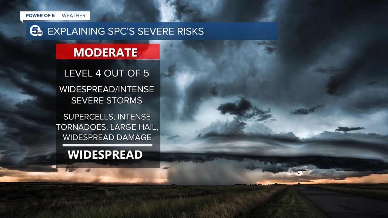
4. MODERATE RISK: Covers an area where widespread severe weather with several tornadoes and/or numerous severe thunderstorms is likely, some of which should be intense. This risk is usually reserved for days with several supercells producing intense tornadoes and/or very large hail or an intense squall line with widespread damaging winds. SPC uses red to show the moderate risk for severe weather.
5. HIGH RISK: (magenta) - Covers an area where a severe weather outbreak is expected from either numerous intense and long-tracked tornadoes or a long-lived Derecho-producing thunderstorm complex that produces hurricane-force wind gusts and widespread damage. This risk is reserved for when high confidence exists in widespread coverage of severe weather with embedded instances of extreme severe (i.e., violent tornadoes or very damaging convective wind events). SPC uses magenta to show the high risk of severe weather.

Below is an example of a severe weather risk from late March 2023 and includes a moderate risk (red), an enhanced risk (orange), a slight risk (yellow) and a marginal risk (green). There is also a light green which shows a general risk for non-severe thunderstorms. The risk below resulted in over 30 deaths, dozens injured and widespread damage across 9 states. Now you know when you hear us mention these categories that it is time to set your severe weather plan in motion and you will need to stay weather aware.

Want the latest Power of 5 weather team updates wherever you go? Download the News 5 App free now: Apple|Android
Download the StormShield app for weather alerts on your iOS and Android device: Apple|Android
Click here to view our interactive radar.
Read and watch the latest Power of 5 forecast here.
Follow the News 5 Weather Team:
Mark Johnson: Facebook & Twitter
Trent Magill: Facebook & Twitter
