


CLEVELAND — The third day of January will feel more like spring, but you need to also prepare for fog and widespread heavy rain. Let's discuss timing and totals:
ALERTS: Dense fog advisory until 3 a.m. Tuesday for Medina, Summit, Portage, Richland, Ashland, Wayne, Stark, and Holmes counties.
Be careful on the roads this evening as travel could become dangerous due to low visibility. Visibility is expected to only be one quarter to one half mile in dense fog. If driving, slow down, use your headlights, and leave plenty of distance ahead of you.
SET UP:
An area of low pressure over the Plains is lifting a warm front over Northeast Ohio tonight. The warm front will cause our temps to briefly jump back into the 60s for Tuesday and Wednesday. As the low slides toward the Midwest, it will drag a cold front east through the area by Wednesday afternoon. The cold front will drop our temperatures by Thursday and into the weekend. The entire system will also bring the return of widespread rain on Tuesday.

TIMING:
Fog will be the biggest issue for Monday evening. After midnight isolated rain showers will begin to increase from the south. By 5 a.m. rain looks to become widespread. Periods of moderate to heavy rain will be likely. The best chance for rain is early on Tuesday, but notice below, hit and miss showers will be possible in the afternoon. As the cold front approaches, another round of rain looks likely Tuesday night and into Wednesday. Temperatures will fall by Thursday from the upper 50s to the 40s and continue to drop into the 30s by Friday. Scroll through the images of Futurecast to get an idea about timing and coverage of the rain.
Early Tuesday....

Tuesday's Commute....

Midmorning Tuesday...

Tuesday Evening....

Early Wednesday...

Wednesday's Morning Commute...

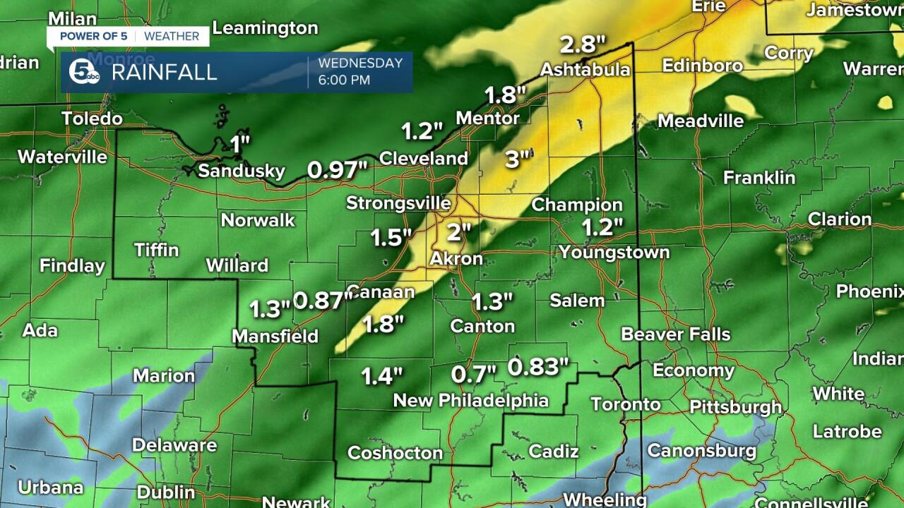
SEVERE POTENTIAL/TOTALS:
Widespread severe weather is not expected on Tuesday, but a few strong storms will be possible as the cold front slides through Tuesday/Wednesday. Winds will be increasing on Tuesday and gusts over 30 mph will be likely. Additionally, The Power of 5 Weather Team will be monitoring the flood potential. By Wednesday, 0.75 - 1.50 inches of rain will be possible across the area. Locally, higher amounts of 2 inches or more will be possible as well. No flood alerts have been issued but we will keep you posted if that changes. Plan for low visibility and ponding on the roadways for the Tuesday and Wednesday morning commutes. Keep with the Power of 5 Weather Team for the latest information!
Want the latest Power of 5 weather team updates wherever you go? Download the News 5 App free now: Apple|Android
Download the StormShield app for weather alerts on your iOS and Android device: Apple|Android
Click here to view our interactive radar.
Read and watch the latest Power of 5 forecast here.
Follow the News 5 Weather Team:
Mark Johnson: Facebook & Twitter
Trent Magill: Facebook & Twitter
