


THURSDAY AFTERNOON UPDATE:
Do not be fooled by the mild February we had. March is bringing back winter, and soon. Our next storm system is moving toward Northeast Ohio right now. Plan for accumulating snow for portions of the Power of 5 viewing area on Friday.
News 5 Chief Meteorologist Mark Johnson gives updates on what to expect heading into Friday morning.
To watch the live stream, click the player below:
ADVISORIES:
A Winter Weather has been issued for the following counties from early Friday morning until early Saturday morning.
- Cuyahoga
- Lake
- Geauga
- Portage
- Ashtabula
- Lorain
- Medina
- Summit
- Erie
- Huron
- Ottawa
- Sandusky
- Seneca
- Trumbull
TIMING:
Rain and snow will spread from west to east shortly after midnight. There will be some dry air to overcome at first, but the atmosphere should become saturated pretty quickly. Expect steady and widespread snow for a few hours Friday morning. The heaviest snow is expected early on Friday when snow rates could exceed half an inch per hour. Therefore, you should plan for a slower morning commute with slick spots and lowered visibility at times.
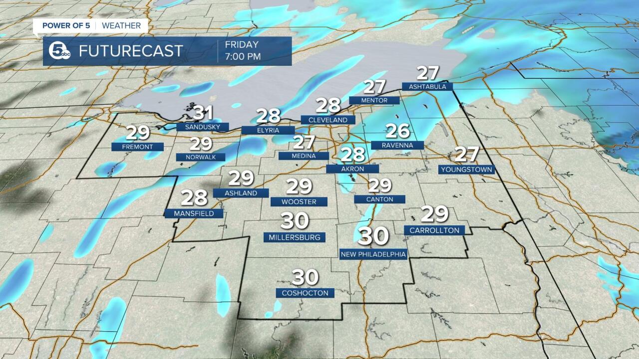
Snow will continue into the afternoon and evening on Friday, especially north of the Route 30 corridor. By Friday evening, wrap-around scattered and lake effect snow will then be the name of the game into early Saturday.
Scroll through the images of Futurecast below to get an idea about timing and coverage.


SNOWFALL TOTALS:
There will be a large range of snow fall totals and impacts across the area. The heaviest snow will be in our northern communities, including the primary snowbelt and smaller totals will be likely farther south. From Route 30 and points north, including Cleveland, will likely see a range of 2-5 inches. This also includes communities in Lorain, Media, Cuyahoga, Erie and Lake Counties. As we move south, 1-3 inches will be more common in the cities of Akron, Canton, Wooster and Ashland. Heading south of Route 30, expect more rain to mix in and most locations will see less than 1 inch of snow.
As the system pulls out of the region towards the northeast by Friday evening, lake-effect snow will kick in. This will bring more snow to the snowbelt region. Another few inches will be possible, especially in Ashtabula, Lake and Geauga counties and the highest totals will be found in the primary snowbelt around 3 to 6 inches for most, but a couple isolated higher amounts.
Check out the updated snowfall map below.

We are continuing to make small tweaks and updates to the forecast. Be sure to stay tuned for the latest from the News 5 Weather Team! We will see things begin to dry out as we head into the morning on Saturday, but things are still looking on the colder side, as highs will only top off in the lower 30s. PLUS there is another chance for snow on Sunday. Winter is certainly not over.
Want the latest Power of 5 weather team updates wherever you go? Download the News 5 App free now: Apple|Android
Download the StormShield app for weather alerts on your iOS and Android device: Apple|Android
Click here to view our interactive radar.
Read and watch the latest Power of 5 forecast here.
Follow the News 5 Weather Team:
Mark Johnson: Facebook & Twitter
Trent Magill: Facebook & Twitter
