


CLEVELAND — This has been one of the driest Septembers in years, but high pressure (the reason we have been so dry lately) is finally fizzling and moving offshore this weekend. A large but disorganized area of showers and storms across the middle of the country will consolidate into one stronger storm by Sunday evening. Before rain arrives, a very warm southerly flow with moisture will bring another rise in temperatures. Highs on Sunday will be in the mid to upper 80s. Heat index values could briefly reach 90 degrees on Sunday afternoon. If you are going to the Browns game, get ready to sweat and stay cool! Do not forget the ponchos for a late-game storm chance.
Scattered showers and downpours are likely by Sunday evening, with a stronger t-storm or two possible. Damaging winds will be the primary concern, along with heavy rain and frequent lightning.
Monday and Tuesday will feature on-and-off showers with periods of heavy rain. While we need rainfall in the midst of drought, we also do not want too much rain too fast, like some of the storms may produce. It will get cooler over the course of the week as the rainy pattern introduces cooler Canadian air with highs down to the low 70s by midweek.
DAILY FORECAST:
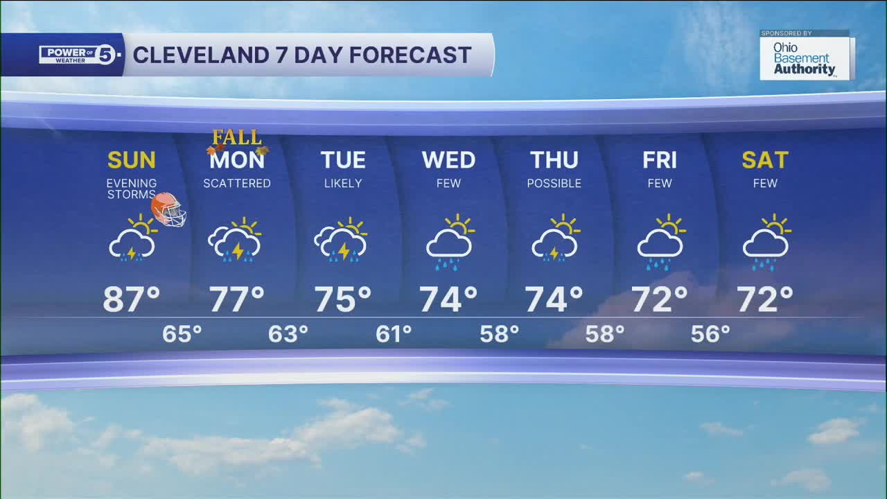
Sunday: More clouds. Humid. Storms Late. | High: 87º
Monday: Scattered rain showers. Few storms. Cooler. | High: 77º
Tuesday: Rain showers and few storms likely. Mostly cloudy.| High: 75º
Wednesday: Few showers. Mostly cloudy.| High: 74º
Thursday: T'showers possible. Mostly cloudy.| High: 74º
Friday: Few showers. Mostly cloudy.| High: 72º
Tuesday: Few showers. Mostly cloudy.| High: 72º
Want the latest Power of 5 weather team updates wherever you go? Download the News 5 App free now: Apple|Android
Click here to view our interactive radar.
Follow the News 5 Weather Team:
Trent Magill: Facebook & Twitter
Katie McGraw: Facebook & Twitter
Phil Sakal: Facebook & Twitter
Allan Nosoff: Facebook & Twitter
