



CLEVELAND —
Lake Erie Helps Us Out Tonight
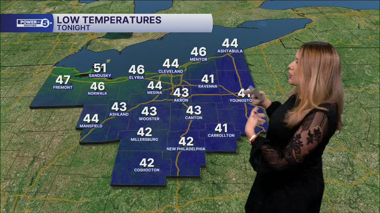
It’ll get chilly again tonight, but most of us should stay too warm for frost. Those north winds will come straight off a relatively warm Lake Erie. That air gets warmed over the lake before moving south into Northeast Ohio, helping keep temps up a bit overnight.
So while it’ll certainly feel crisp, frost shouldn’t be as widespread of a concern for most of us. Temperatures in the low to mid 40s will be common, with a few inland communities dipping into the upper 30s.
Fab Friday
Another easy fall day is ahead, but that bright sunshine could actually be the biggest weather headache. We’ll have plenty of sun with highs in the lower to middle 60s once again. If you’re driving east during the morning commute and west for the evening, watch the sun glare.
The low October sun can sit right in your line of sight, so keep the sunglasses handy and give yourself a little extra room between cars.
Let's talk! News 5 will be in Cuyahoga Falls Friday afternoon from 4 to 6:30 pm and we want to hear from you! If you have a story idea, or just want to chat about the weather, we would love to meet you! The weather looks perfect, too!
A Weekend Warm-Up
Our wind changes direction this weekend. South winds take over and start pulling warmer air back into Northeast Ohio. We should notice the difference, especially by Sunday. We may even squeeze out a 70-degree day Sunday, with another shot at 70 Monday. For late October, we’ll take it. That is running about 10 degrees above average!
Any rain chances look to hold off until mid week (and they truthfully do not look very impressive). The pattern should turn wetter by the end of October and early November. Be sure to check back for the Halloween forecast and if it will be a trick or a treat!
5-Day Forecast:
Thursday Night: Clear & cool. Patchy fog. | Low: 45º
Friday: Mostly sunny & seasonable. | High: 63º
Saturday: Mostly sunny & seasonable. | High: 64º
Sunday: Mostly sunny & warm. | High: 68º
Monday: A few more clouds. | High: 69º
Learn the lingo: The Power of 5 Weather Team wants to get you your forecast closer to home. We have broken NEO into 5 separate and distinct regions. Find your region to get your hyper-local forecast!
- Cleveland Metro Region: Cuyahoga County. This region includes cities such as Cleveland, Parma, Westlake, Berea, Strongsville, Independence, Solon, Beachwood, and Euclid.
- Snowbelt Region: Lake, Geauga, and Ashtabula Counties. This includes cities such as Mentor, Geneva, Ashtabula, Bainbridge, Chardon, Burton, and Orwell.
- Akron-Canton Region: Summit, Stark, and Portage Counties. This region includes cities such as Akron, Canton, Hudson, Ravenna, Mantua, Alliance, and Canal Fulton.
- West Region: Lorain, Medina, Erie, Huron, Richland, and Ashland Counties. This region includes cities such as Lorain, Wellington, Medina, Lodi, Ashland, Mansfield, Willard, and Sandusky.
- South Region: Wayne, Holmes, Tuscarawas, Carroll Counties. This region includes Wooster, Millersburg, New Philadelphia, Strasburg, Mineral City, Carrollton, and Newcomerstown
You can send us photos and short videos by filling out the form below:
Want the latest Power of 5 weather team updates wherever you go? Download the News 5 App free now: Apple|Android
Click here to view our interactive radar.
Follow the News 5 Weather Team:
Trent Magill: Facebook & Twitter
Katie McGraw: Facebook & Twitter
Phil Sakal: Facebook & Twitter
Allan Nosoff: Facebook & Twitter
