

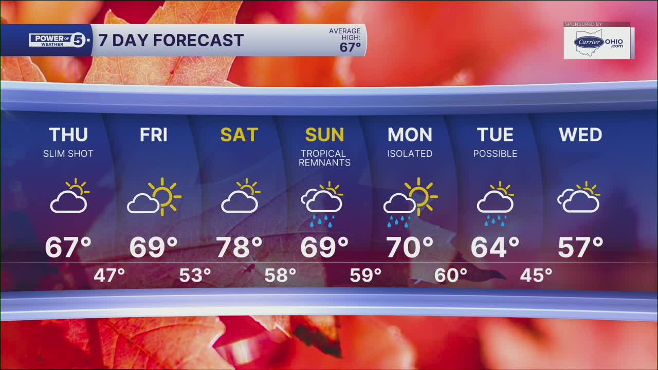


CLEVELAND — A cold front slides through tonight, bringing a noticeable change for Thursday. Temps will be about 10 degrees cooler, with highs closer to 65 to around 70 degrees. Northwest winds will gust up to 25 mph. Clouds will be decreasing overnight, so the majority of Thursday will feature a mostly sunny sky.
Friday stays dry with increasing clouds and temperatures. It gets even warmer on Saturday with temps returning to the mid- and upper-70s! Most of Saturday will stay dry, but we will be keeping a close eye on Tropical Storm (eventually Hurricane) Isaias that will make landfall late Friday/early Saturday near the panhandle of Florida.
Moisture from the system will move northward into the Ohio Valley over the weekend. Sunday looks like the wettest day, with periods of rain likely and the potential for a good soaking rainfall. Some rain could linger into Monday before conditions begin to improve.
Regional Highlight: The "Skeletal" Snowbelt Region...
Meteorologist Katie McGraw spent the afternoon and evening in the Snowbelt Region at the Holden Arboretum in Kirtland on Wednesday. It was a beautiful, warm, and breezy day, perfect to check out the stunning landscapes of dense forest as well as their Skeleton Grove (huge dressed-up skeletons?! Yes, please!). In the highlight video below, you can see an image of one of these skeletons featured!
October is also a big month for the arboreta and botanical garden because of the changing fall leaves! Have you started to notice the leaves changing?! If you want to check out everything the Holden Arboretum has to offer this weekend, Thursday, Friday, and Saturday all look like great options weather-wise, because widespread tropical rain is expected on Sunday. This is true for all of NEO as well.
5-Day Forecast:
Thursday: Stray AM showers and cooler. | High: 68º
Friday: Partly sunny. Seasonable. | High: 67º
Saturday: Super warm! Still dry. | High: 77º
Sunday: Watching closely. Rain returns. | High: 72º
Monday: Isolated showers. Breezy.| High: 70º
Learn the lingo: The Power of 5 Weather Team wants to get you your forecast closer to home. We have broken NEO into 5 separate and distinct regions. Find your region to get your hyper-local forecast!
- Cleveland Metro Region: Cuyahoga County. This region includes cities such as Cleveland, Parma, Westlake, Berea, Strongsville, Independence, Solon, Beachwood, and Euclid.
- Snowbelt Region: Lake, Geauga, and Ashtabula Counties. This includes cities such as Mentor, Geneva, Ashtabula, Bainbridge, Chardon, Burton, and Orwell.
- Akron-Canton Region: Summit, Stark, and Portage Counties. This region includes cities such as Akron, Canton, Hudson, Ravenna, Mantua, Alliance, and Canal Fulton.
- West Region: Lorain, Medina, Erie, Huron, Richland, and Ashland Counties. This region includes cities such as Lorain, Wellington, Medina, Lodi, Ashland, Mansfield, Willard, and Sandusky.
- South Region: Wayne, Holmes, Tuscarawas, Carroll Counties. This region includes Wooster, Millersburg, New Philadelphia, Strasburg, Mineral City, Carrollton, and Newcomerstown
You can send us photos and short videos by filling out the form below:
Want the latest Power of 5 weather team updates wherever you go? Download the News 5 App free now: Apple|Android
Click here to view our interactive radar.
Follow the News 5 Weather Team:
Trent Magill: Facebook & Twitter
Katie McGraw: Facebook & Twitter
Phil Sakal: Facebook & Twitter
Allan Nosoff: Facebook & Twitter
