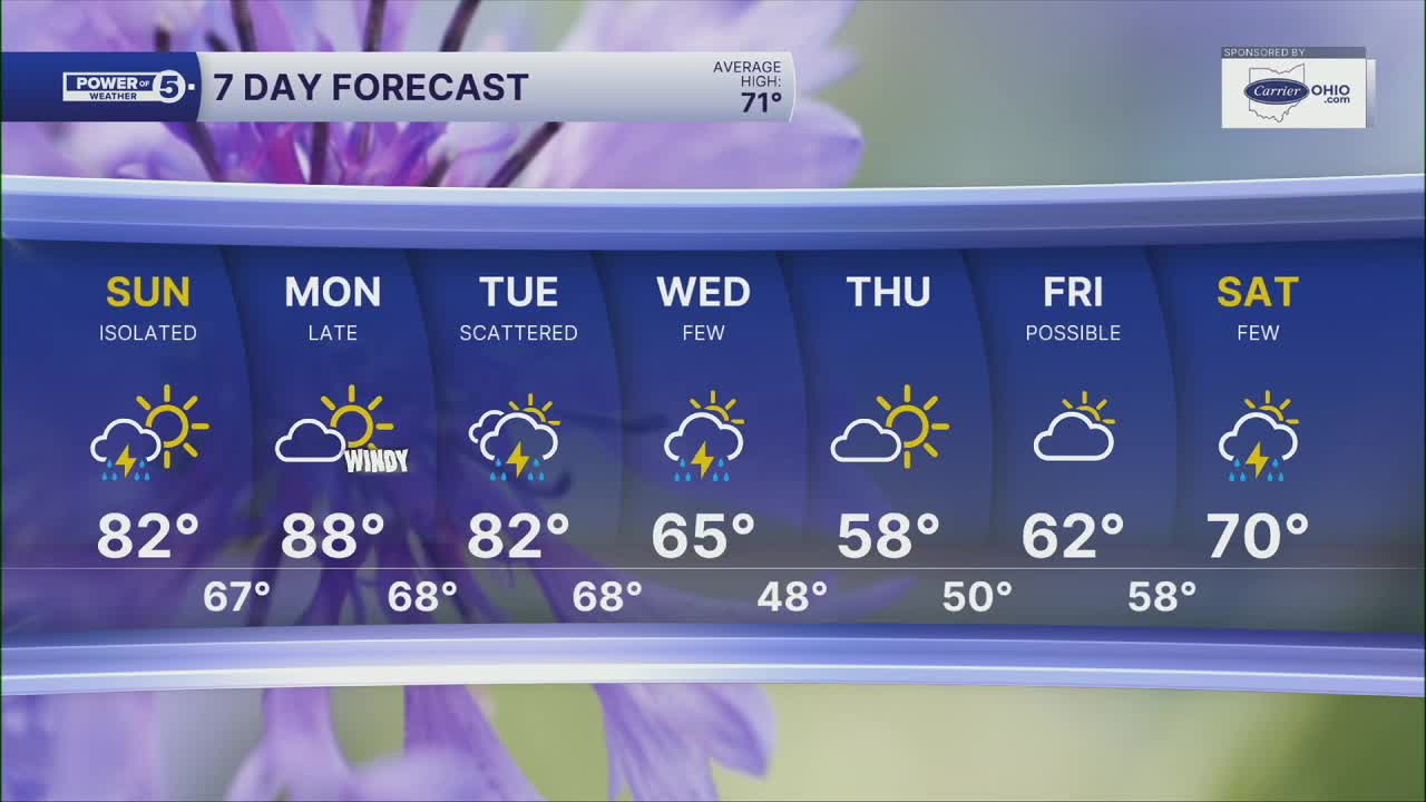


CLEVELAND — It's an important forecast for the Cleveland Marathon on Sunday. Plan on a warm start to the day with temperatures in the lower 60s for the start of the race and jumping fast through the morning. Plan on lower 70s by 10am with the lower 80s in the afternoon. And humid! Super sweaty for the runners, something we haven't had to deal with so far.
That humidity has an impact on more than just runners. Isolated t-storms are possible, too. There will be a lot more dry time on Sunday than we had on Saturday. That's also why temps will jump a bit more. Lower 80s!
Hottest temperatures of the season (so far) will be here to kick off the new work week! We've touched the lower 80s but haven't seen the middle or upper 80s... yet. Some spots could touch 90º Monday!
We're looking dry, too. It'll be windy with gusts to near 30mph, with only an isolated storm possible. And that looks like it'll be late in the day. We will have to watch a decaying line of storms Monday evening in our western communities. A better chance for storms is on Tuesday and Wednesday. These storms will be ahead of a cold front and usher in the return of cooler temperatures for the rest of the work week.
DAILY FORECAST:
Sunday: Isolated t-showers possible, very warm. | High: 82º
Monday: Windy & hot with a slim shot at thunder late.| High: 88º
Tuesday: Scattered storms. Could be strong. | High: 82º
Wednesday: Wettest early as temps fall. | High: 65º
Thursday: Drying out and Cooler. | High: 58º
Friday: Partly cloudy and below avg. | High: 62º
Want the latest Power of 5 weather team updates wherever you go? Download the News 5 App free now: Apple|Android
Click here to view our interactive radar.
Follow the News 5 Weather Team:
Trent Magill: Facebook & Twitter
Katie McGraw: Facebook & Twitter
Phil Sakal: Facebook & Twitter
Allan Nosoff: Facebook & Twitter
