



CLEVELAND — Tuesday's weather was terrific! That will continue tonight with high clouds, calm winds, and cool temperatures in the 50s for much of NEO. It will be a hair milder than the last two nights.
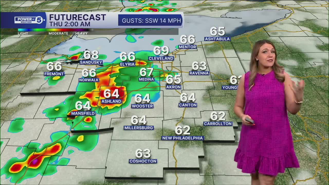
We're a bit warmer on Wednesday with highs reaching the lower 80s. Clouds increase through the day, but most of the daylight hours stay rain-free. Rain and a few thunderstorms arrive Wednesday evening into the overnight hours.
West Region Highlight: Stay alert tonight as storms approach
Our West communities are the focus as we look ahead to storms returning by Wednesday night. As previously mentioned, much of Wednesday will be dry. Storms will be moving into our west region after sunset on Wednesday. The line of storms is expected to weaken as it approaches our area, but the greatest impacts will be across Erie, Huron, Ashland, Richland, Lorain, and Medina Counties. The severe weather risk is greater to the NW of NEO, including Detroit, Toledo, and Fort Wayne, but we will be watching for strong wind gusts, lightning, and heavy rain as these storms move into our viewing area. As the line continues to weaken, the chance for storms drops the farther east you live.
Looking ahead:
After morning showers and storms on Thursday, we will have to watch for additional pop-up storms with highs near 80 degrees. If you're heading to the Browns game Thursday evening, keep an eye on the forecast as a few showers or thunderstorms may still be around. The greater chance for severe weather on Thursday is to the east of NEO, so hopefully we miss out on any damaging storms for all 5 regions.
The good news? Drier weather returns for the weekend with comfortable temps and lower humidity. But summer is NOT over yet! By next week, temperatures are expected to climb into the mid and maybe even the upper 80s!!
5-Day Forecast
Tuesday Night: High clouds, calm winds, cool temps. | Low: 59º
Wednesday: Showers & storms possible late. Near norm. | High: 82º
Thursday: Few showers and storms. | High: 80º
Friday: Isolated shower/storm. Cooler. | High: 77º
Saturday: Sun, cloud mix, warm. | High: 78º
Learn the lingo: The Power of 5 Weather Team wants to get you your forecast closer to home. We have broken NEO into 5 separate and distinct regions. Find your region to get your hyper-local forecast!
- Cleveland Metro Region: Cuyahoga County. This region includes cities such as Cleveland, Parma, Westlake, Berea, Strongsville, Independence, Solon, Beachwood, and Euclid.
- Snowbelt Region: Lake, Geauga, and Ashtabula Counties. This includes cities such as Mentor, Geneva, Ashtabula, Bainbridge, Chardon, Burton, and Orwell.
- Akron-Canton Region: Summit, Stark, and Portage Counties. This region includes cities such as Akron, Canton, Hudson, Ravenna, Mantua, Alliance, and Canal Fulton.
- West Region: Lorain, Medina, Erie, Huron, Richland, and Ashland Counties. This region includes cities such as Lorain, Wellington, Medina, Lodi, Ashland, Mansfield, Willard, and Sandusky.
- South Region: Wayne, Holmes, Tuscarawas, Carroll Counties. This region includes Wooster, Millersburg, New Philadelphia, Strasburg, Mineral City, Carrollton, and Newcomerstown
Want the latest Power of 5 weather team updates wherever you go? Download the News 5 App free now: Apple|Android
Click here to view our interactive radar.
Follow the News 5 Weather Team:
Trent Magill: Facebook & Twitter
Katie McGraw: Facebook & Twitter
Phil Sakal: Facebook & Twitter
Allan Nosoff: Facebook & Twitter
