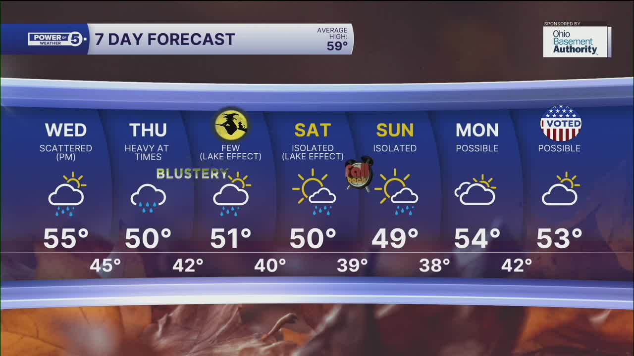


CLEVELAND — Today was beautiful! Tons of sunshine with seasonable temperatures. It was a breezy day, though, and winds will remain elevated for the next several days, with the strongest winds on Thursday. It will continue to be blustery on Halloween.
Get ready for some "tricks" starting tomorrow. A system to our west will dig south before moving NE into the Ohio River Valley. This system will bring a lot of moisture with it. Plan for a dry and frigid start to the day tomorrow. Clouds will be increasing during the afternoon with rain to our south. Rain will increase from the south to the north throughout Wednesday evening.
Rain should become widespread & heavier on Wednesday night and into Thursday morning. Thursday looks SOAKED. Rainfall totals will likely be a bit lower in our westernmost communities, where 0.5'' to 1'' of rain is possible. 1-2'' are expected for much of the viewing area. A couple of spots could pick up over 2 inches. It will also be gusty with NE winds 15-25 mph and gusts over 30 mph.
Rain chances come down on Friday, however there it does not look completely dry either. A few lingering, lighter showers are expected on Halloween. There may even be a few more lake effect showers this weekend.
It will also be chilly! The highs on Friday look to only be in the low 50s. That means by the time all the witches and ghosts are out trick-or-treating, it will be even cooler with temps in the 40s, and remember it will be blustery too!
DAILY FORECAST:
Tuesday night: Mostly clear, chilly, and breezy. | Low: 38º
Wednesday: Rain possible late. More clouds. | High: 56º
Thursday: Rain likely. Heavy at times. Breezy. | High: 51º
Halloween: Light showers. Cooler and blustery. | High: 52º
Saturday: Lake-effect possible. Chilly. | High: 52º
Want the latest Power of 5 weather team updates wherever you go? Download the News 5 App free now: Apple|Android
Click here to view our interactive radar.
Follow the News 5 Weather Team:
Trent Magill: Facebook & Twitter
Katie McGraw: Facebook & Twitter
Phil Sakal: Facebook & Twitter
Allan Nosoff: Facebook & Twitter
