


CLEVELAND — After a chilly and breezy day, it will be a COLD but calm night. Plan for temperatures in the upper 20s and low 30s overnight! Meanwhile, winds are decreasing, while clouds are increasing ahead of our next system that will bring a wintry mix and chilly rain to NEO on Tuesday.
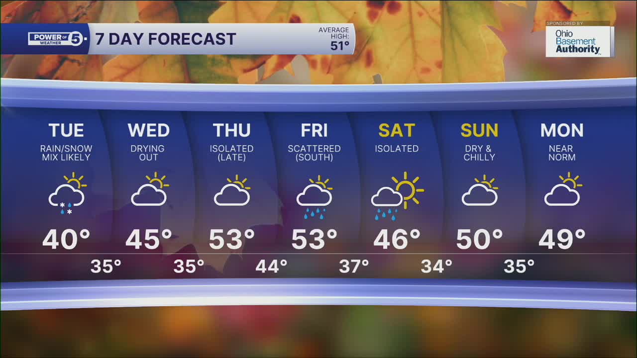
This next system is coming from the southwest. Wet snow, sleet, and cold rain will be moving in by Tuesday morning from west to east. Due to the timing, this wintry mess could impact the morning drive. Give yourself extra time and go slow! It will remain chilly on Tuesday, but temperatures will eventually climb into the upper 30s and low 40s. This increase will allow for more of a chilly rain vs wet snow during the afternoon.
Precip amounts will range across NEO, with the highest chance for rain/mix in our southern and western communities, with lower impacts farther north and east. Rainfall amounts could be over a quarter of an inch farther south, but in the primary snowbelt and farther north, totals look much lower. (likely below a tenth of an inch).
High pressure (high and dry) will return for Wednesday, allowing for dry weather to return for Wednesday and much of Thursday. The next significant rain chance holds off until late Thursday and Friday. We are keeping an eye on it, but as of Monday evening, this next system is favoring our southern communities again. Stay tuned!
DAILY FORECAST:
Monday Night: Cold, calmer winds, increasing clouds. | Low: 30º
Tuesday: Mostly cloudy with rain and wet snow showers. | High: 40º
Wednesday: Dry again. Warmer. | High: 45º
Thursday: Isolated showers possible late. Seasonable and breezy. | High: 53º
Friday: More rain, especially south. Warm and breezy. | High: 53º
Saturday: Mostly cloudy. Drying out. Cooler. | High: 46º
Want the latest Power of 5 weather team updates wherever you go? Download the News 5 App free now: Apple|Android
Click here to view our interactive radar.
Follow the News 5 Weather Team:
Trent Magill: Facebook & Twitter
Katie McGraw: Facebook & Twitter
Phil Sakal: Facebook & Twitter
Allan Nosoff: Facebook & Twitter
