


CLEVELAND — Stay warm tonight! We did not even crack 70 degrees today in Cleveland, the first time since June 1st! That chill will continue tonight. The coldest morning will be on Wednesday. Lows in Downtown Cleveland could be as chilly as the low 50s. We will be in record-breaking territory across NEO with mid-40s expected inland! A couple of stray showers are possible tonight into early Wednesday as well.
After a fallish morning, temperatures will be a touch warmer on Wednesday, with highs in the 70s again, but that is still below average for the end of August. Typically, afternoon temps are in the low 80s this time of year, so we will still be running about 10 degrees below average tomorrow.
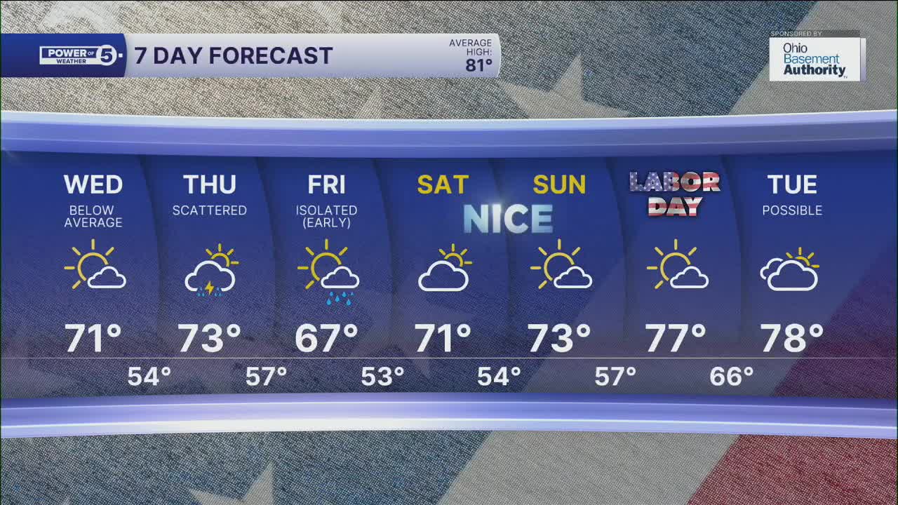
The best chance for rain this week appears to be on Thursday and into Friday, with scattered thunderstorms and a gradual drying trend expected on Friday. These storms will keep our temperatures on the cool side for the rest of the week, including the holiday weekend. Friday will likely fall back into the upper 60s, with 70s returning this weekend and a gradual warming trend by Labor Day. Temperatures are expected to range from the upper 70s to perhaps the low 80s by Monday, and it looks to stay dry all weekend, too!
DAILY FORECAST:
Tuesday Night: Chilly digits. Stray showers.| Low: 52º
Wednesday: Cold start. Brighter but still cool. | High: 71º
Thursday: Partly sunny. Scattered t-showers. | High: 73º
Friday: Isolated showers. Cooler. | High: 67º
Saturday: Partly sunny. Touch warmer. | High: 71º
Sunday: More sunshine. Still below average. | High: 73º
Labor Day: A Bit milder, still dry. | High: 77º
Want the latest Power of 5 weather team updates wherever you go? Download the News 5 App free now: Apple|Android
Click here to view our interactive radar.
Follow the News 5 Weather Team:
Trent Magill: Facebook & Twitter
Katie McGraw: Facebook & Twitter
Phil Sakal: Facebook & Twitter
Allan Nosoff: Facebook & Twitter
