


CLEVELAND — What a weekend of weather thus far! What started as a typical cloudy and chilly Saturday morning turned into a whiteout with snow squall warnings midday. Not only was there thundersnow, which happens once or a few times each winter, but there were NINE strikes within an hour from the same squall. That is unheard of!
The heavy snow is behind us, but more snow is likely tonight and early Monday. That is part of an arctic cold front that will unlock yet even colder air for Monday afternoon and into the night. A coating to two inches is likely with isolated pockets of three inches in the primary snowbelt between midnight and noon. Snow will end for most of Northeast Ohio by noon, but some lake effect is likely to return later Monday afternoon for Lake and coastal Ashtabula counties. Why those areas and not farther inland? The wind direction will be more southwesterly instead of northwesterly like most lake effect events thus far this winter.
Models have not been consistent and have shown the snow to miss Ohio completely, but looking at the pattern and ingredients in place, there will be an opportunity for the coastline on the east side for several inches of lake effect snow on Monday evening.
Dangerous cold continues to move in, with dropping temperatures during the day on Monday. It will start near 20 around sunrise, but fall to 10 by sunset, feeling like below zero. Wind chills will be between 15 and 20 below zero on Tuesday morning.
This pattern is holding serve for a few more weeks. Several clippers will keep this active pattern alive with more light-to-steady snow likely on Wednesday, possible on Thursday, and possible again this weekend.
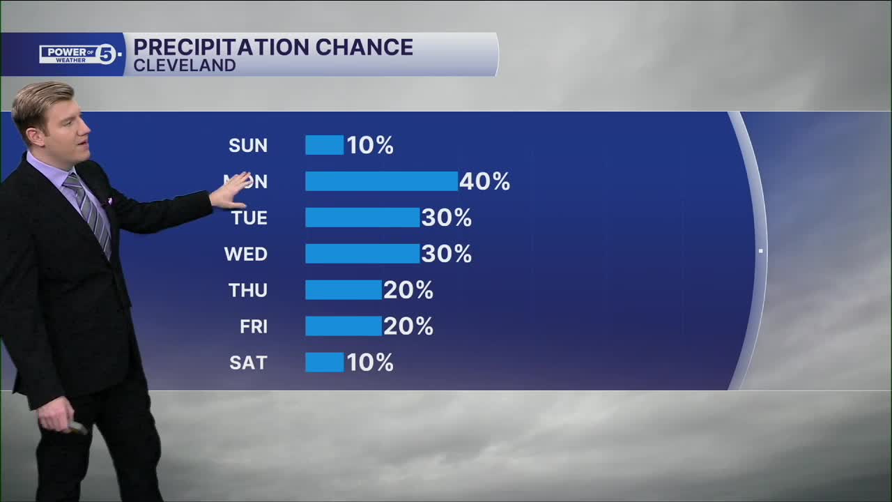
DAILY FORECAST:
Today: Mostly sunny. Frigid. | High: 19º
MLK Day: Scattered snow in the morning. Lake effect possible late (east). Frigid. | High: 17º (falling)
Tuesday: Lake effect snow possible early. Dangerous cold. | High: 12º
Wednesday: Snow likely, especially in the morning. Warmer. | High: 30º
Thursday: Still a chance of snow showers. | High: 27º
Thursday: Another chance of snow showers. | High: 29º
Want the latest Power of 5 weather team updates wherever you go? Download the News 5 App free now: Apple|Android
Click here to view our interactive radar.
Follow the News 5 Weather Team:
Trent Magill: Facebook & Twitter
Katie McGraw: Facebook & Twitter
Phil Sakal: Facebook & Twitter
Allan Nosoff: Facebook & Twitter
