



CLEVELAND — It's Fall, y'all! The seasons officially changed at 8:05 pm on Tuesday, but the weather got a head start this week with chilly temperatures and dreary clouds. Clouds, gusty winds, and cool temps will keep Northeast Ohio feeling more like October than late September. Winds will continue to gust up to 30 mph, making it feel even cooler at times.
Although the clouds looked threatening all day, rain chances were limited, and light rain will continue this evening...but heavier rain is possible overnight into Wednesday morning for some communities.
Power of 5 Regions Spotlight: West and South Regions
The heaviest rainfall overnight and into Wednesday morning should be in our west and south regions. The window for heavier rainfall looks to be from about 3 am until 9 am Wednesday. Any flooding issues will be isolated, but another 0.5 to 1 inch of rain will be possible across portions of Richland, Ashland, Wayne, Holmes, Tuscarawas and Carroll Counties.
Lakeshore Impact
Another big weather story is along Lake Erie. A Small Craft Advisory is in effect with waves building to 4 to 8 feet. The lake water is still relatively warm, hovering near 70 degrees, but it's too dangerous to swim, with a high risk of rip currents. Alerts for Lake Erie remain in effect until 10 pm Wednesday.
Wednesday: Wetter, But Not A Washout
Rain becomes more widespread Wednesday, and a few downpours are likely in the morning. The good news is this does not look like an all-day washout. We should begin to dry out during the afternoon and evening, with clearing skies by Wednesday.
Temps stay stuck in the middle 60s, keeping that autumn feel firmly in place. Lows by Thursday
Looking Ahead...
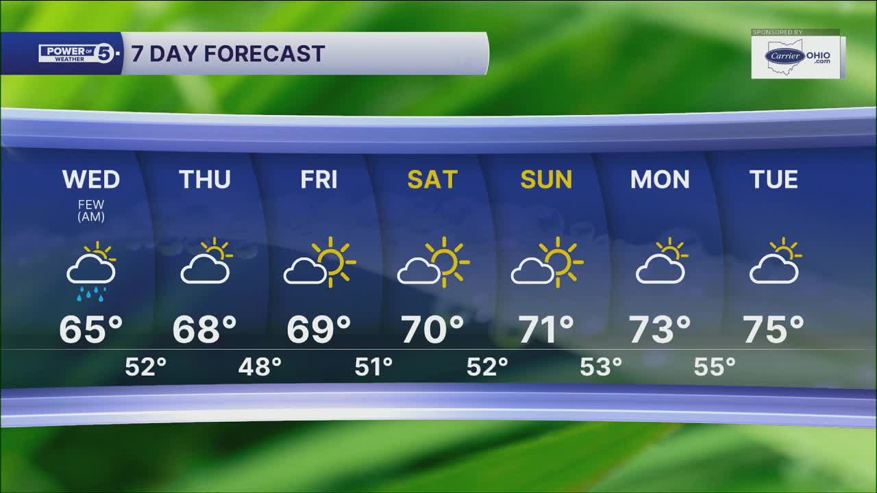
The rest of the week looks dry with a mix of clouds and sunshine. It will remain cool, especially at night. Thursday and Friday morning could have widespread 40s across NEO! Brrr! But then temps will gradually climb about a degree or two each day. By the weekend, highs are expected to return to around 70 degrees. The warming trend looks to continue into next week. October could start ABOVE average.
5-Day Forecast
Wednesday: Few downpours. Breezy & still cool. | High: 67º
Thursday: Mostly dry, but still cool. | High: 68º
Friday: More sunshine and a touch warmer. | High: 69º
Saturday: More sun, closer to the norm. | High: 70º
Sunday: Bright & comfy. | High: 71º
Learn the lingo: The Power of 5 Weather Team wants to get you your forecast closer to home. We have broken NEO into 5 separate and distinct regions. Find your region to get your hyper-local forecast!
- Cleveland Metro Region: Cuyahoga County. This region includes cities such as Cleveland, Parma, Westlake, Berea, Strongsville, Independence, Solon, Beachwood, and Euclid.
- Snowbelt Region: Lake, Geauga, and Ashtabula Counties. This includes cities such as Mentor, Geneva, Ashtabula, Bainbridge, Chardon, Burton, and Orwell.
- Akron-Canton Region: Summit, Stark, and Portage Counties. This region includes cities such as Akron, Canton, Hudson, Ravenna, Mantua, Alliance, and Canal Fulton.
- West Region: Lorain, Medina, Erie, Huron, Richland, and Ashland Counties. This region includes cities such as Lorain, Wellington, Medina, Lodi, Ashland, Mansfield, Willard, and Sandusky.
- South Region: Wayne, Holmes, Tuscarawas, Carroll Counties. This region includes Wooster, Millersburg, New Philadelphia, Strasburg, Mineral City, Carrollton, and Newcomerstown
You can send us photos and short videos by filling out the form below:
Want the latest Power of 5 weather team updates wherever you go? Download the News 5 App free now: Apple|Android
Click here to view our interactive radar.
Follow the News 5 Weather Team:
Trent Magill: Facebook & Twitter
Katie McGraw: Facebook & Twitter
Phil Sakal: Facebook & Twitter
Allan Nosoff: Facebook & Twitter
