


CLEVELAND — This will be one of the strongest storms, by pressure, to cross the Great Lakes, since Christmastime 2022, three years ago. The official scientific term is 'bombogenesis' where the storm rapidly intensifies (24 millibars of pressure in 24 hours). For more on that, make sure to read more and share Allan's explainer on Facebook:
If you aren't following Allan, or any of our Power of 5 team, make sure you are so you do not miss out on important winter weather updates. Links are at the bottom of this article.
The initial burst of heavy rain has crossed Northeast Ohio and warmer air is surging in for the afternoon and especially evening. Temperatures will then soar into the 50s and 60s by late Sunday afternoon, along with increasing wind. Most of the heavy rain will likely stay north over the lake, but occasional isolated downpours are possible the rest of the day, especially north of Akron, which means some rain is likely for the Browns game, while missing out on the worst of this part of the storm.
The cold front around midnight will be a game-changer. It could even contain an isolated severe thunderstorm. Gusts of 60 mph, small hail, and flooding downpours are possible as the cold front with a squall line passes through. Behind the front, Arctic cold comes crashing down.
Wind gusts of 40 to 60 mph are likely late Sunday night through Monday evening. The temperatures will tumble down to the 20s by mid-morning Monday.
The lake effect machine is turned back on later Monday, as snow showers take over by Monday evening, with a burst of moderate snow possible for the evening commute Monday, and a few fluffy inches of snow are possible for most. Lake effect could continue through Tuesday evening, with 6-inch potential in the primary snowbelt, where squalls persist.
The lake effect snow takes a brief break Tuesday night into Wednesday, but returns as the ball drops Wednesday night alongside another clipper. A few more inches of snow are possible ringing in 2026. It will feel frigid with temperatures topping out near 20 and lows near 10-15.
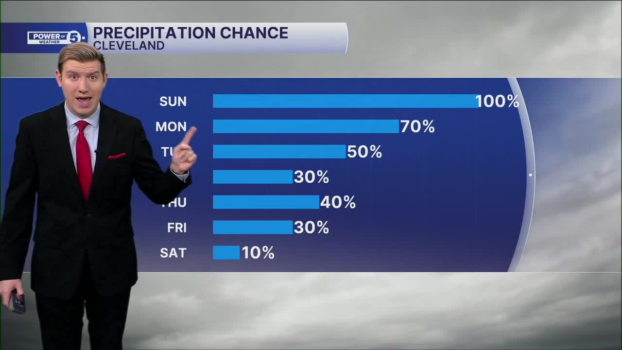
DAILY FORECAST:
Today: Scattered showers and a few strong t-storms possible. Windy & warm. | High: 62º
Monday: Temperatures Tumble. Lake effect snow possible. | High: 25º
Tuesday: Breezy & cold. Lake effect snow possible. | High: 27º
New Year's Eve: Cold. Lake effect snow possible. | High: 29º
New Year's Day: Cold to start 2026. Lake effect snow possible. | High: 22º
Friday: Even colder. Lake effect snow possible. | High: 19º
Want the latest Power of 5 weather team updates wherever you go? Download the News 5 App free now: Apple|Android
Click here to view our interactive radar.
Follow the News 5 Weather Team:
Trent Magill: Facebook & Twitter
Katie McGraw: Facebook & Twitter
Phil Sakal: Facebook & Twitter
Allan Nosoff: Facebook & Twitter
