



CLEVELAND —
A cool fall day is on tap across Northeast Ohio.
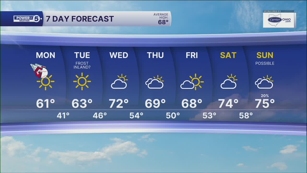
We'll see plenty of sunshine today, but don't let the sun fool you. Highs only reach around 61 degrees, and a breeze with gusts up to 20 mph will keep it feeling a little cooler at times.
Tonight brings the coldest air we've seen in a while. The wind drops off, the sky stays clear, and temps tumble to around 41 in Cleveland. Many inland spots away from the cities will fall into the 30s.
That could lead to patchy frost by early Tuesday morning, especially in rural areas. If you still have sensitive plants outside, it's a good idea to cover them or bring them indoors tonight. The lakeshore, Cleveland, and other larger cities should stay warm enough to avoid frost.
The cool air doesn't stick around for long. Sunshine returns Tuesday, and temps climb back into the middle 60s during the afternoon. Even warmer weather arrives Wednesday, with highs pushing into the 70s under a mostly sunny sky.
Regional Highlight: Inland Frost Risk Tonight
If you live away from Lake Erie and outside the bigger cities, you may wake up to a little frost on the lawn Tuesday morning.
The combination of a clear sky, light wind, and chilly overnight temps will allow many inland communities to dip into the 30s. Gardeners will want to take a few minutes this evening to protect any plants that are still hanging on.
Near the lakeshore, temperatures stay several degrees warmer, so frost is not expected in Cleveland or most shoreline communities. Once the chilly start is out of the way, Tuesday quickly turns into a beautiful fall afternoon with sunshine and temps back in the 60s.
Frost potential for some early in the week:
The weekend looks and feels much more like October. Just like the baseball saying 'fall classic,' it will be classic fall weather. Make sure the fall jackets stick around because the cooler pattern sticks around through the first half of next week. We also remain dry for days to come.
With the lingering chill, we may even see our first frost away from the lakeshore by Tuesday morning!
5-Day Forecast:
Monday: Cold front passes with some clouds. Cooler and breezy. | High: 62º
Tuesday: First frost of season inland. Sunny and cool. | High: 65º
Wednesday: Bounce-back temps. Partly sunny. | High: 72º
Thursday: Partly sunny. Still looking dry. | High: 70º
Friday: Partly sunny. Still looking dry. | High: 70º
Learn the lingo: The Power of 5 Weather Team wants to get you your forecast closer to home. We have broken NEO into 5 separate and distinct regions. Find your region to get your hyper-local forecast!
- Cleveland Metro Region: Cuyahoga County. This region includes cities such as Cleveland, Parma, Westlake, Berea, Strongsville, Independence, Solon, Beachwood, and Euclid.
- Snowbelt Region: Lake, Geauga, and Ashtabula Counties. This includes cities such as Mentor, Geneva, Ashtabula, Bainbridge, Chardon, Burton, and Orwell.
- Akron-Canton Region: Summit, Stark, and Portage Counties. This region includes cities such as Akron, Canton, Hudson, Ravenna, Mantua, Alliance, and Canal Fulton.
- West Region: Lorain, Medina, Erie, Huron, Richland, and Ashland Counties. This region includes cities such as Lorain, Wellington, Medina, Lodi, Ashland, Mansfield, Willard, and Sandusky.
- South Region: Wayne, Holmes, Tuscarawas, Carroll Counties. This region includes Wooster, Millersburg, New Philadelphia, Strasburg, Mineral City, Carrollton, and Newcomerstown
You can send us photos and short videos by filling out the form below:
Want the latest Power of 5 weather team updates wherever you go? Download the News 5 App free now: Apple|Android
Click here to view our interactive radar.
Follow the News 5 Weather Team:
Trent Magill: Facebook & Twitter
Katie McGraw: Facebook & Twitter
Phil Sakal: Facebook & Twitter
Allan Nosoff: Facebook & Twitter
