


CLEVELAND — After another dry spell, rain is returning to NEO...soon! A cold front is crossing through the region and will bring rain, breezy winds, and much cooler temperatures by midweek.
Clouds will be increasing tonight, as well as a gradual increase in the rain potential. It will remain mild with lows in the 60s. Rain chances increase after 4 am, and widespread showers are expected to occur by Tuesday morning's commute. The highest chance for rain will be Tuesday morning, but plan for on-and-off rain throughout the entire day on Tuesday, with a few thunderstorms. The severe threat is low, but not zero, and storms could produce heavy rain at times, and minor flooding is possible.
The ground is very dry, and while it is great we are getting some much-needed rain, too much rain too fast could lead to runoff flooding. Repeated rounds of heavy rain could also lead to localized flooding. Rainfall amounts should be around a half an inch to 1.5 inches by early Wednesday, but there could be a few communities that pick up over 2 inches of rain. Rain will gradually decrease by Tuesday night and into Wednesday morning. Behind the front on Wednesday, expect drier and much cooler air to round out the workweek.
We actually look to fall BELOW average by then! Highs will struggle to reach the low 60s on Wednesday afternoon and fall to near 40 degrees Thursday morning, with 30s inland. Some patchy frost will be possible across our inland communities for the first time this season!
The rest of the week will be seasonable and sunny - a beautiful October week!
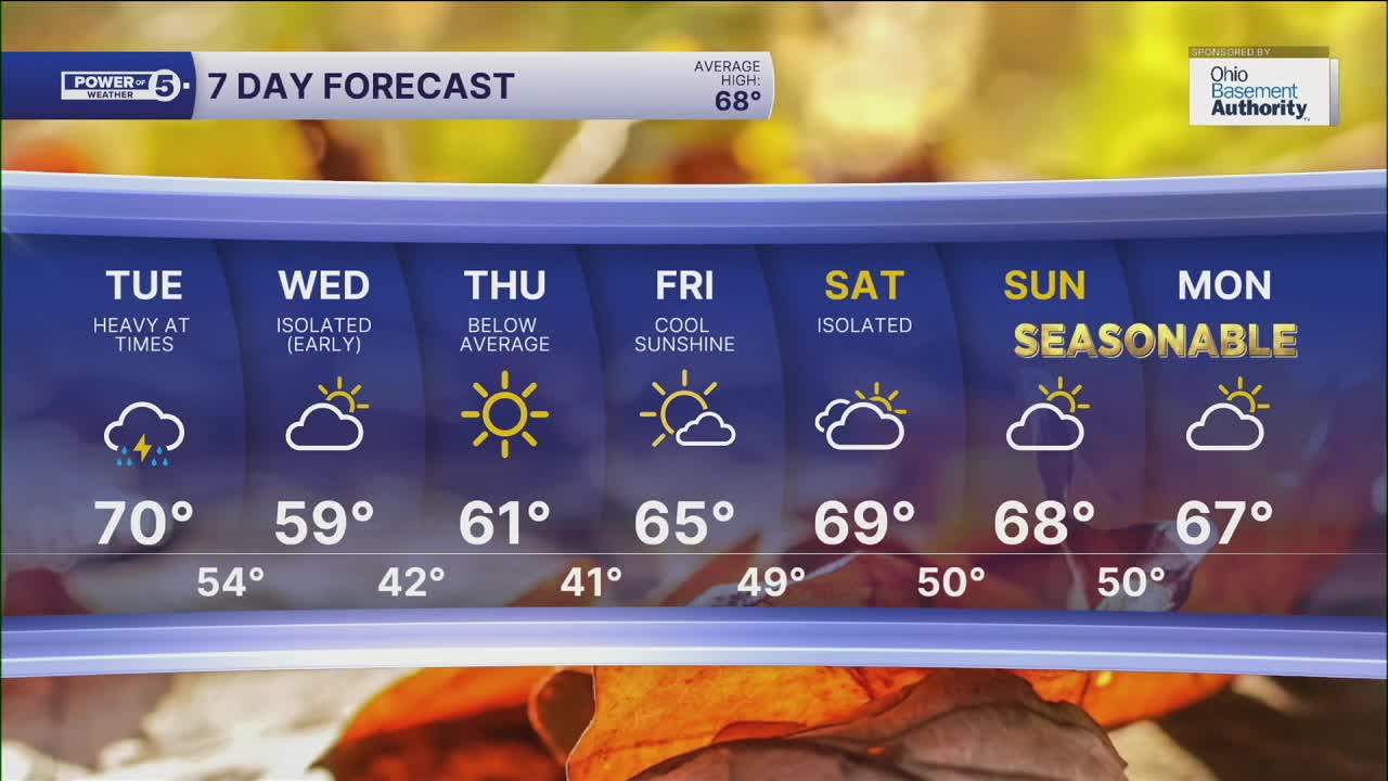
DAILY FORECAST:
Monday Night: Mostly cloudy. Rain returns. | Low: 64º
Tuesday: Waves of heavy rain. | High: 71º
Wednesday: Drying early but staying chilly. | High: 60º
Thursday: Bright but still cool. | High: 61º
Friday: Seasonable.| High: 65º
Saturday: Slim shot at rain. | High: 68º
Want the latest Power of 5 weather team updates wherever you go? Download the News 5 App free now: Apple|Android
Click here to view our interactive radar.
Follow the News 5 Weather Team:
Trent Magill: Facebook & Twitter
Katie McGraw: Facebook & Twitter
Phil Sakal: Facebook & Twitter
Allan Nosoff: Facebook & Twitter
