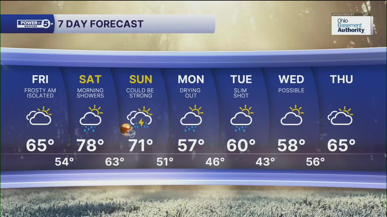


FROST ADVISORIES have been issued for the majority of NEO for Friday Morning. Plan for temperatures in the low to mid 30s away from the lake shore tonight. For more information, click this link.
The chilly temperatures and frosty conditions are thanks to the wind subsiding as well as a clear sky, allowing for the temperatures to drop like a rock! It will be cold and frosty to start your Friday, but it will end up being a sunny day as well as a bit warmer during the afternoon on Friday, thanks to a change in the wind direction, from north to south. A warm front is also moving through Friday night and will bring a sudden warmup for the weekend.
That warm front will bring the chance for a few showers early on Saturday. Temperatures will be even warmer to begin the weekend, with highs approaching 80 degrees on Saturday. Between Saturday's warm front and Sunday's cold front, there will be plenty of dry time in between for outdoor activities.
The trailing cold front and associated low pressure will bring much more significant rain and potentially strong storms to the area. Right now, this is a conditional threat for severe weather based on WHEN the rain and storms arrive.
Rain could begin as soon as the wee hours of Sunday morning, or wait till midday. The timing will be critical with this storm because the longer the front waits into the afternoon, the higher the severe threat grows. There will be pockets of heavy rain regardless, along with quite windy conditions on Sunday and Sunday night.
Wind gusts of 40 to 50 mph will be possible as the front moves through and lasts through early Monday. Cooler air will filter in for the start of the new work week behind the front, as highs drop into the mid and upper 50s, along with a few lingering rain chances on Monday. On top of the rain, get ready for a wild temperature swing in both directions over the next few days.
DAILY FORECAST:
Tonight: Clear and chilly and frosty. | Low: 42º
Friday: Partly sunny. Not as cool. | High: 65º
Saturday: Few early showers. Stray shower or storm late. Much warmer. | High: 78º
Sunday: Rain likely. Storms possible. Windy. | High: 71º
Monday: Early shower chance. Cooler again and still breezy. | High: 58º
Tuesday: Isolated shower chance. Seasonable. | High: 61º
Wednesday: Shower chance. Cooler again. | High: 59º
Want the latest Power of 5 weather team updates wherever you go? Download the News 5 App free now: Apple|Android
Click here to view our interactive radar.
Follow the News 5 Weather Team:
Trent Magill: Facebook & Twitter
Katie McGraw: Facebook & Twitter
Phil Sakal: Facebook & Twitter
Allan Nosoff: Facebook & Twitter
