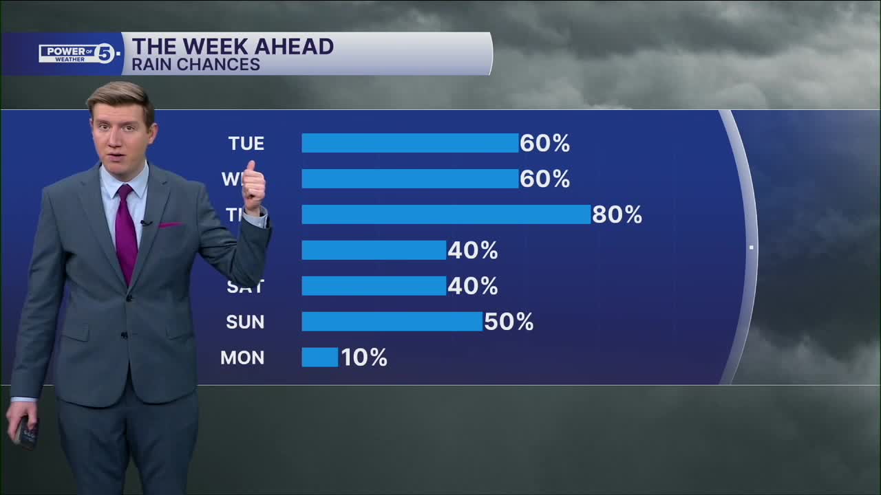


CLEVELAND — Mother Nature finally got the memo that it is not February anymore. Yet, the weather will jump all the way to May by this weekend! While it will get much warmer, that will also unlock a lot of moisture, and the likelihood of rain showers every day through at least Saturday.
It was still a cold start to the workweek with highs not even cracking 40 in Cleveland, and lower 40s inland. With lows dipping to the upper 20s around midnight, there is the worry of freezing rain before it gets warm enough for plain rain Tuesday morning. The best chance for freezing rain, between 3 and 7 a.m., is in the higher elevations east, like interior Geauga and Ashtabula counties.
There isn't much moisture available, so any precipitation will be light for the AM drive, and the mist and drizzle will continue on and off through the day. A steadier round of showers is possible for the evening commute, but this is just the first of a parade of storms.
More on-and-off showers and light rain is likely on Wednesday, primarily for the second half of the day. Then, the real party begins Thursday as another, much more potent storm will unlock more warmth and moisture, meaning 60s are likely, but so are scattered downpours and rumbles.
Between Tuesday and Saturday, at least an inch and a half is likely, with isolated spots of over 2-3 inches where downpours stall out (mainly Thursday). While each storm will not bring too much, the fact that there will be a consistent dose of new rain on top of dry ground is a recipe for scattered minor flooding, particularly in spots that do not typically see it.
If the jet stream lifts far enough north to push most of the rain over the lake, AND avoid a lake breeze, 70s are likely everywhere on Saturday, which would be within five degrees of a record in most locations. Given this is still several days away, check back for forecast updates.
DAILY FORECAST:
Monday: More clouds and cold. | High: 42º
Tuesday: Scattered ice/rain mix to rain. | High: 45º
Wednesday: Warming up with showers possible. | High: 54º
Thursday: Better shot at rain and possible t-storms. | High: 62º
Friday: Showers possible. 70s inland. | High: 68º
Want the latest Power of 5 weather team updates wherever you go? Download the News 5 App free now: Apple|Android
Click here to view our interactive radar.
Follow the News 5 Weather Team:
Trent Magill: Facebook & Twitter
Katie McGraw: Facebook & Twitter
Phil Sakal: Facebook & Twitter
Allan Nosoff: Facebook & Twitter
