


CLEVELAND — After a snowy end to your Friday, temperatures will begin to tumble tonight into the start of the weekend.
Morning temperatures to begin the weekend will be below zero, and not 'warming' much. Highs will only top off in the upper single digits to lower teens. Wind Chills will be well below zero, and could be as cold as -24° at times.
Lake effect snow will then develop on Saturday with the arctic blast. Lake Huron still has open water, and Lake Erie has enough open water for fuel. That means additional snowfall of a few inches is likely where squalls persist through Saturday afternoon.
Another weak clipper moves in by Sunday morning and could bring another round of light snow to the region. Accumulations will be light, with an inch or less anticipated. Temperatures will once again be frigid, as highs only 'warm' into the teens Sunday afternoon, with sub-zero wind chills at times.
There is some hope for seeing seasonable temperatures, but we will have to be patient. Highs are trending warmer by Tuesday and next Wednesday...stay tuned!
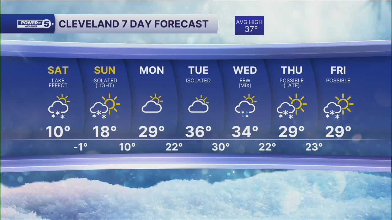
DAILY FORECAST:
Saturday: Lake effect snow possible. Frigid. Wind Chills to -25°.| High: 9º
Sunday: Another clipper possible with morning snow showers. | High: 18º
Monday: Warmer. Mostly cloudy. | High: 29º
Tuesday: Mostly cloudy. Seasonable. Isolated flakes. | High: 36º
Wednesday: Mix possible. Mostly cloudy. | High: 34º
Thursday: Snow showers possible. Below freezing again. | High: 29º
Friday: Snow showers possible. Cold. | High: 29º
Want the latest Power of 5 weather team updates wherever you go? Download the News 5 App free now: Apple|Android
Click here to view our interactive radar.
Follow the News 5 Weather Team:
Trent Magill: Facebook & Twitter
Katie McGraw: Facebook & Twitter
Phil Sakal: Facebook & Twitter
Allan Nosoff: Facebook & Twitter
