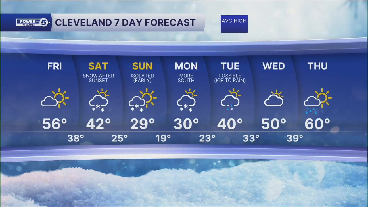


CLEVELAND — On Friday, highs will top off in the low to mid 50s for many, under mostly sunny skies. Unfortunately, the warmth will not last much longer than the end of the work week; colder air moves in for this weekend.
The weekend will be much colder, especially Saturday night and into Sunday. 40s midday Saturday will plummet to the low 20s by Sunday morning, with a few snow showers likely after sunset with a clipper. Temps struggle even to reach 30, with many locations only topping off in the upper 20s on Sunday. A quick inch or two is possible with this clipper Saturday evening through early Sunday morning.
Then, we are keeping a close eye on the start of next workweek as two separate storms could both impact us, or be near misses. Monday's storm, as of now, is expected to slide south and clip us with a snow shower or two. Tuesday's storm is now expected to be stronger and warmer, meaning a transition from snow to rain on Tuesday. This storm will then be the start of a major pattern change. Spring might finally be here for more than just a day or two by the end of the week! Stay tuned for updates on that.
DAILY FORECAST:
Friday: More sunshine, warmer and breezy. | High: 56º
Saturday: More clouds. Isolated snow possible late. | High: 44º
Sunday: Colder. More snow possible. | High: 29º
Monday: Snow Possible. Watching Closely. | High: 30º
Tuesday: Isolated Rain/Snow Possible. Watching Closely. | High: 40º
Wednesday: Clearing and warming up. | High: 50º
Want the latest Power of 5 weather team updates wherever you go? Download the News 5 App free now: Apple|Android
Click here to view our interactive radar.
Follow the News 5 Weather Team:
Trent Magill: Facebook & Twitter
Katie McGraw: Facebook & Twitter
Phil Sakal: Facebook & Twitter
Allan Nosoff: Facebook & Twitter
