


CLEVELAND — A WIND ADVISORY is in effect from 4am Saturday morning thru 1pm Saturday afternoon for Lorain, Cuyahoga, Lake, & Ashtabula Counties. Wind gusts between 40 & 50 mph likely.
Another strong, fast-moving Alberta Clipper low pressure system will slide southeast thru Ohio tonight. Ahead of this strong arctic cold front, expect temperatures to rise into the upper 20s to near 30 degrees between 2 & 4 am. Then once the cold front moves thru, temperatures will crash. In fact, we'll be in the teens in the north and lower 20s in the south by sunrise. This storm system will bring a quick burst of snow, generally an inch or less thru the early to mid-morning hours.
Saturday will stay windy and cold. Skies will be mostly cloudy thru the days. A few light snow showers during the morning just about anywhere. And a few lingering lake effect snow showers east into the snow belt during the afternoon. Total snow from this Clipper System will total an inch or less in most spots. Perhaps a little bit more in the snow belt. Winds will once again be blustery. Gusts above 35 to 50 mph during the morning, gusting 20 to 30 miles per hour during the afternoon. Temperatures will hover in the teens and lower 20s during the afternoon.
All-Star Sunday should be partly to mostly cloudy. It will be blustery. But we will be dry all day with temperatures climbing into the middle and upper 40s!
Stay tuned for more Power of 5 Weather updates! For a full, in depth look at this week's storm check out this story: https://www.news5cleveland.com/weather/weather-news/wild-weather-system-hits-cleveland-ahead-of-nba-all-star-weekend
FORECAST HEADLINES
- Another Alberta Clipper tonight
- More Arctic Air Saturday
- Another shot at light snow Saturday morning
- Windy all day long
- Dry & milder for All-Star Sunday
DETAILED FORECAST
Friday Night: WIND ADVISORY 4am thru 1pm. Cloudy skies. Scattered snow after midnight. Accumulations less than 1 inch most spots. Windy. Gusts above 35 mph. | Low: 10º
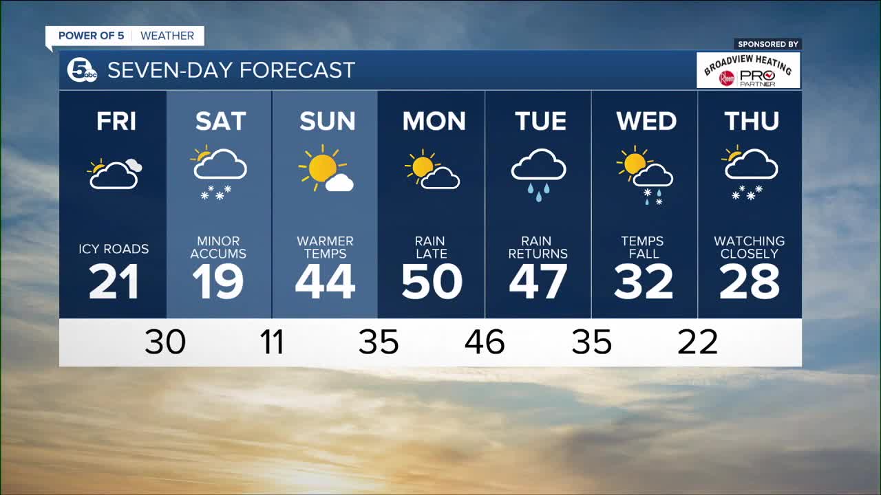
Saturday: Cold & blustery with a few snow showers possible. | High: 19º
Sunday: Drying out with warmer temperatures expected. | High: 48º
Monday: Partly cloudy. Mild. Rain late | High: 50º
Tuesday: Rain returns. | High: 54º
Download the News 5 app for the latest weather updates:
Follow the News 5 Weather Team:
Mark Johnson: Facebook & Twitter
Trent Magill: Facebook & Twitter
Remeisha Shade: Facebook & Twitter
Katie McGraw: Facebook & Twitter
