


CLEVELAND — A few stray rain or snow showers can't be ruled out late this evening, with the better shot after midnight, with temperatures in the mid to upper 30s for most tonight. Temperatures will surge on Sunday. We'll go from the 30s pre-dawn Sunday to the 70s by the afternoon. Gusty winds will return with the warmth (but not as strong as Friday).
Wind Advisory in effect for areas along and west of I-71 and along I-90 from Cleveland towards the Snowbelt from 2 PM Sunday until 8 AM Monday. Southerly winds of 20 to 30 mph, along with gusts up to 50 mph will make for tricky travel and even more power outages.
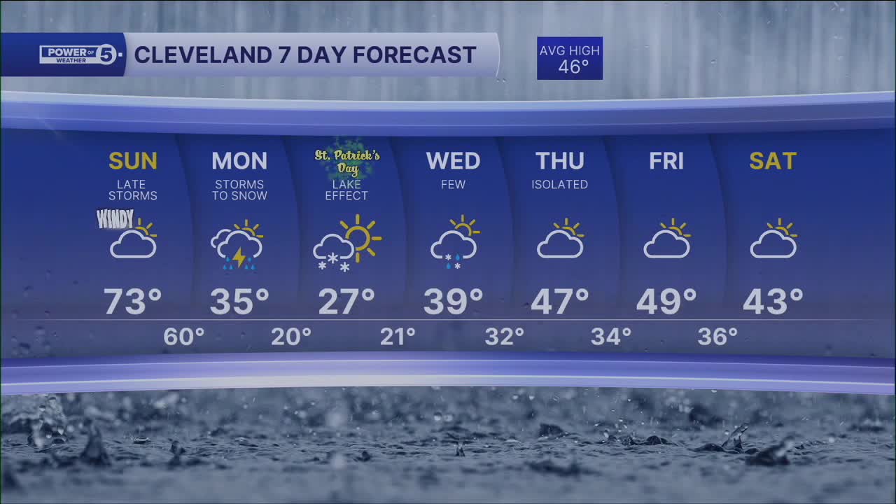
The yo-yo temperature trend continues as the rebound on Sunday is only one day, with highs in the upper 60s and lower 70s.
Next week starts ROUGH! The next system will continue to bring gusty winds and storms late Sunday night into early Monday morning. As temperatures crash, storms will change to snow by the end of Monday morning and lake effect sets up on St. Patrick's Day.
If you are getting your green on for the St. Paddy's Day parade, plan to dress VERY warm! Highs will not break 32° on Tuesday and wind chills will be even colder!
We will then see a return to more normal March conditions by the end of the week, with highs in the upper 40s by Thursday and Friday.
DAILY FORECAST:
Sunday: Warm & windy before storms return. | High: 73º
Monday: Heavy rain, strong wind, dropping temps... taking over late. | Temps: 50s -> 30s
St. Patrick's Day: Frigid with lake effect snow. | High: 27º
Wednesday: Few rain/snow showers. Warmer. | High: 39º
Thursday: Isolated shower. Seasonable temps. | High: 47º
Friday: More clouds. Touch warmer. | High: 49º
Saturday: Mostly cloudy. Chilly. | High: 43º
Want the latest Power of 5 weather team updates wherever you go? Download the News 5 App free now: Apple|Android
Click here to view our interactive radar.
Follow the News 5 Weather Team:
Trent Magill: Facebook & Twitter
Katie McGraw: Facebook & Twitter
Phil Sakal: Facebook & Twitter
Allan Nosoff: Facebook & Twitter
