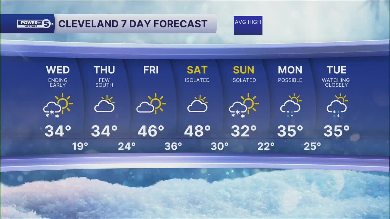


CLEVELAND — Our next shot at snow rolls in tonight. It's a quick-moving Albert Clipper. Temps will be holding near 32º, so plan on a slush trace up to 2" of snow, with highest totals in the snowbelt region. Most of the snow will linger into the wee hours of Wednesday morning. The good news is that the snow moves out by sunrise, but we'll still have to clean the cars off. Make sure you allow time for that as we start our Wednesday.
Temperatures will be closer to average in most areas, with highs in the upper 30s and lower 40s, but a lake breeze might keep our northern communities in the lower 30s for the afternoon.
Temperatures will begin to warm again for the end of the work week into the start of the weekend, with highs in the mid to upper 40s Friday and Saturday. More sun to be had on Friday, but an isolated snow shower will be possible late Saturday.
Colder air filters in by Sunday and it could be a messy start to the new work week, with rain/snow possible. Something we'll keep an eye on!
DAILY FORECAST:
Wednesday: Snow before sunrise. Partly sunny and warmer south.| High: 34º
Thursday: Cold again. Few snow showers south. | High: 34º
Friday: More sunshine, seasonable. | High: 46º
Saturday: Even warmer, Isolated snow possible. | High: 48º
Sunday: Colder. Isolated snow possible. | High: 32º
Monday: Rain/Snow Possible. Watching Closely. | High: 35º
Tuesday: Rain/Snow Possible. Watching Closely. | High: 35º
Want the latest Power of 5 weather team updates wherever you go? Download the News 5 App free now: Apple|Android
Click here to view our interactive radar.
Follow the News 5 Weather Team:
Trent Magill: Facebook & Twitter
Katie McGraw: Facebook & Twitter
Phil Sakal: Facebook & Twitter
Allan Nosoff: Facebook & Twitter
