


SMALL CRAFT ADVISORY, HIGH RIP CURRENT & WATERSPOUT RISK - Tuesday and early Wednesday
Stay warm tonight! It will be chilly! Temperatures at night will drop into the 40s for many inland areas on Tuesday morning. It will be warmer closer to the lake with temperatures in the 50s.
You can copy and paste Monday's forecast for Tuesday. Most of us won't see 70º again on Tuesday. That chilly air (60s) moving over a "warm" Lake Erie (mid-70s) is fueling lake effect rain. Thunder is possible, but the bigger concern is heavy rain. There will be on-and-off quick bursts of rain, followed by a mixture of sun and clouds, which will continue to be the trend. We may even get in on some waterspouts with these squalls.
The coldest morning will be on Wednesday. Lows in Downtown Cleveland could be as chilly as 51 degrees. Some records will be tested on Tuesday night! Temperatures try to warm by mid-week, with highs in the mid-70s, but that is still below average for the end of August. Typically, afternoon temps are in the low 80s this time of year.
The best chance for rain this week looks to be on Thursday and into Friday. The holiday weekend is looking cool but dry and should gradually warm each day.
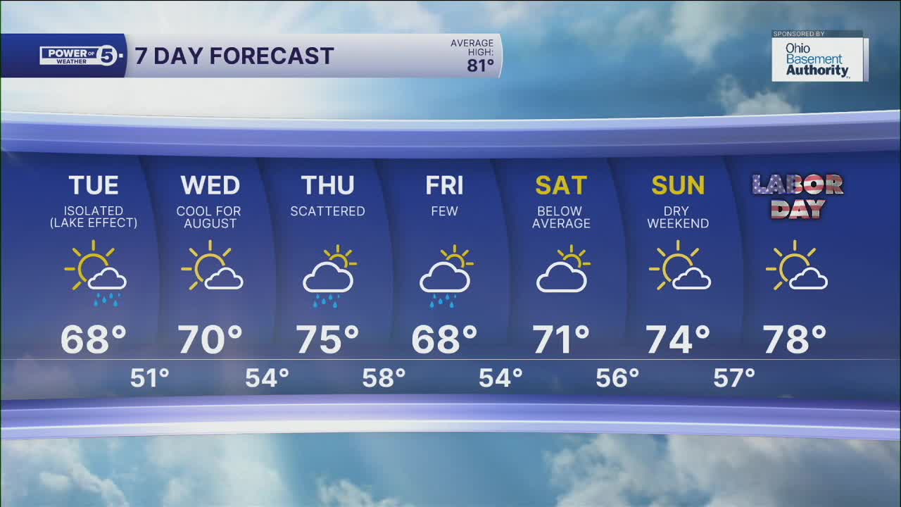
DAILY FORECAST:
Monday Night: Chilly temps! 40s inland.| Low: 56º
Tuesday: Cool again. Lake effect rain showers are still possible.| High: 68º
Wednesday: Cold start. Brighter but still cool. | High: 70º
Thursday: Partly sunny. Scattered t-showers. | High: 75º
Friday: Isolated showers. Cooler. | High: 73º
Saturday: Partly sunny. Touch warmer. | High: 76º
Sunday: More sunshine. Still below average. | High: 77º
Labor Day: A Bit milder, still dry. | High: 77º
Want the latest Power of 5 weather team updates wherever you go? Download the News 5 App free now: Apple|Android
Click here to view our interactive radar.
Follow the News 5 Weather Team:
Trent Magill: Facebook & Twitter
Katie McGraw: Facebook & Twitter
Phil Sakal: Facebook & Twitter
Allan Nosoff: Facebook & Twitter
