



CLEVELAND —
Fabulous Friday Forecast...for the most part
After a soggy start to your Thursday, the weather improved significantly by the evening. The clearing and drying continue tonight. It will be a mostly clear, starry night. But it will also get a bit cool tonight! Temperatures by Friday morning will be in the mid to upper 50s for much of NEO. But it's only a brief chill; Friday brings plenty of sunshine and a pleasant afternoon with highs in the low 80s. The forecast looks fantastic for most of the day and for most of our regions.
West Region Spotlight
There is only a slim chance of a stray thunderstorm by Friday night/early Saturday in our west region. It appears that it will be a weakening line of thunderstorms, so by the time they arrive in our west region, they should be falling apart as they progress east. However, it continues to show up on our future radar, so we wanted to be sure to give a heads-up that Erie, Huron, Lorain, Ashland, and Richland Counties could see a couple of showers after 9 pm on Friday. More storms are expected on Saturday.
Looking ahead:
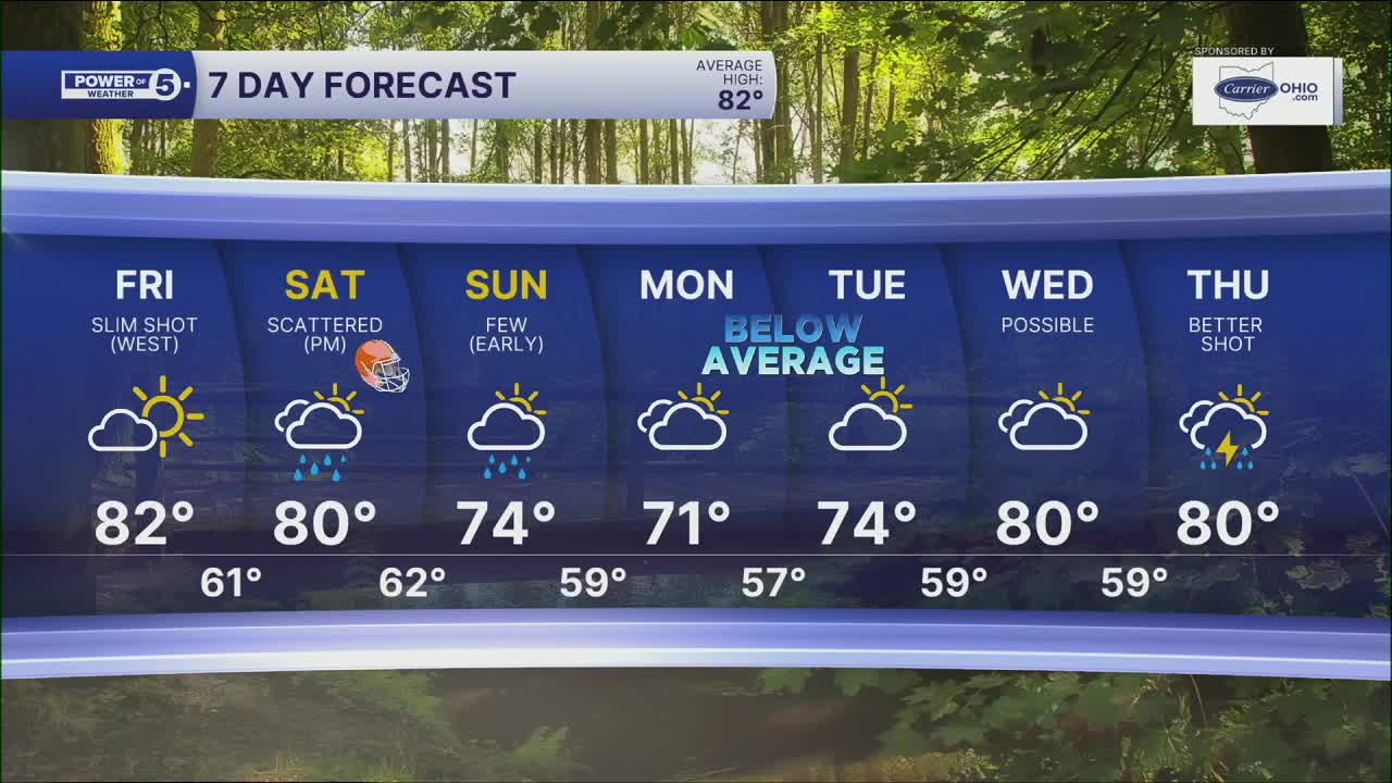
Storms return for all of NEO by Saturday afternoon and evening. We're keeping a close eye on the timing because it could impact the Browns game. As of Thursday evening, it appears storms will roll into NEO between 2 and 4 pm. Anyone heading downtown should plan for rain, especially during the second half of the game. These storms could also become strong or severe, with damaging wind gusts as the main concern, but remember any storm is dangerous when there is lightning. When thunder roars, get indoors! A few showers will linger on Sunday, but this weekend does not look like a washout.
Thursday Night: Clear & cool. | Low: 59º
Friday: Mostly sunny & comfortable. A stray storm late west. | High: 82º
Saturday: Scattered rain by the afternoon & evening. | High: 80º
Sunday: A few lingering Showers. | High: 74º
Monday: Slim shot at rain. | High: 71º
Learn the lingo: The Power of 5 Weather Team wants to get you your forecast closer to home. We have broken NEO into 5 separate and distinct regions. Find your region to get your hyper-local forecast!
- Cleveland Metro Region: Cuyahoga County. This region includes cities such as Cleveland, Parma, Westlake, Berea, Strongsville, Independence, Solon, Beachwood and Euclid.
- Snowbelt Region: Lake, Geauga and Ashtabula Counties. This includes cities such as Mentor, Geneva, Ashtabula, Bainbridge, Chardon, Burton and Orwell.
- Akron-Canton Region: Summit, Stark and Portage Counties. This region includes cities such as Akron, Canton, Hudson, Ravenna, Mantua, Alliance, and Canal Fulton.
- West Region: Lorain, Medina, Erie, Huron, Richland and Ashland Counties. This region includes cities such as Lorain, Wellington, Medina, Lodi, Ashland, Mansfield, Willard, and Sandusky.
- South Region: Wayne, Holmes, Tuscarawas, Carroll Counties. This region includes Wooster, Millersburg, New Philadelphia, Strasburg, Mineral City, Carrollton, and Newcomerstown
Want the latest Power of 5 weather team updates wherever you go? Download the News 5 App free now: Apple|Android
Click here to view our interactive radar.
Follow the News 5 Weather Team:
Trent Magill: Facebook & Twitter
Katie McGraw: Facebook & Twitter
Phil Sakal: Facebook & Twitter
Allan Nosoff: Facebook & Twitter
