



CLEVELAND —
Storm Threat Winding Down
Storms are finally winding down this evening, but some rain and thunder will linger through the first half of the overnight. Temperatures will begin to cool into the lower 60s and upper 50s during the overnight, as a taste of fall begins to move in for the start of the new week. Along with the cooler air, a breezy Sunday with gusts of 20 to 30 mph will be possible, especially in our Snowbelt Region.
Power of 5 Spotlight: Snow Belt
Winds will be gusty at times, with some gusts between 20 and 30 mph on Sunday for parts of the Snowbelt region. Isolated showers and some thunder will be possible early on Sunday and then again for the evening across the Snowbelt region.
Looking ahead: Drier and cooler
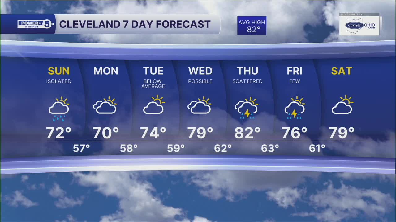
Our temperatures will be a good 5-10 degrees cooler between Saturday and Sunday. There will be an isolated shot at a t-shower on Sunday, but there should be a lot more dry time compared to Saturday.
Below-average temperatures will linger into the work week. Highs on Monday could be in the low 70s! It will be comfortable and dry until mid-week. The taste of fall does not last long... we will be back into the upper 70s and low 80s by the middle of the week, along with more storm chances.
5-Day Forecast
Sunday: A few lingering Showers. Cooler temps.| High: 73º
Monday: Cool temperatures. Sun and clouds. | High: 71º
Tuesday: More sun, Comfortable. | High: 75º
Wednesday: Looking GREAT. | High: 79º
Learn the lingo: The Power of 5 Weather Team wants to get you your forecast closer to home. We have broken NEO into 5 separate and distinct regions. Find your region to get your hyper-local forecast!
- Cleveland Metro Region: Cuyahoga County. This region includes cities such as Cleveland, Parma, Westlake, Berea, Strongsville, Independence, Solon, Beachwood, and Euclid.
- Snowbelt Region: Lake, Geauga, and Ashtabula Counties. This includes cities such as Mentor, Geneva, Ashtabula, Bainbridge, Chardon, Burton, and Orwell.
- Akron-Canton Region: Summit, Stark, and Portage Counties. This region includes cities such as Akron, Canton, Hudson, Ravenna, Mantua, Alliance, and Canal Fulton.
- West Region: Lorain, Medina, Erie, Huron, Richland, and Ashland Counties. This region includes cities such as Lorain, Wellington, Medina, Lodi, Ashland, Mansfield, Willard, and Sandusky.
- South Region: Wayne, Holmes, Tuscarawas, Carroll Counties. This region includes Wooster, Millersburg, New Philadelphia, Strasburg, Mineral City, Carrollton, and Newcomerstown
Want the latest Power of 5 weather team updates wherever you go? Download the News 5 App free now: Apple|Android
Click here to view our interactive radar.
Follow the News 5 Weather Team:
Trent Magill: Facebook & Twitter
Katie McGraw: Facebook & Twitter
Phil Sakal: Facebook & Twitter
Allan Nosoff: Facebook & Twitter
