


CLEVELAND — This wild weekend weather will take a turn for the stormy into Sunday. It was a beautiful Saturday as highs reached 80 degrees in Cleveland and across a lot of Northeast Ohio. The typical average last 80-degree day occurs on October 4th, not the 18th, so it is a much later occurrence in 2025. This is also likely the last 80-degree day of 2025.
That heat is all fuel for thunderstorms. Plan for more significant rain and potentially strong storms in the area for the second half of the weekend. A few storms are possible Saturday evening/night in western Ohio, but most of our viewing area will stay dry until Sunday.
As of Saturday evening, the heaviest rain is likely to roll through with a few rumbles around midday, between 10 a.m. and 2 p.m. from west to east. This timing would avoid a worst-case scenario with severe storms and lightning that could have significantly impacted the Browns game. Lightning aside, windswept downpours are still expected for tailgaters and for the first part of the game if the storm slows down slightly. While there is a chance for a strong or severe storm, widespread wind gusts of 40 to 50 mph should be expected starting Sunday morning and continuing into the night, with any embedded stronger storm holding stronger gusts than that.
Once the line of storms passes, there will be ongoing on/off showers with 30 to 40 mph gusts all the way through Sunday night. That ushers in much colder, below-average weather to start the workweek.
DAILY FORECAST:
Tonight: Slight storm chance west, otherwise mostly cloudy and humid. | Low: 66º
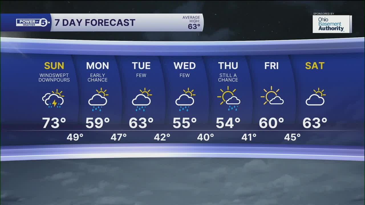
Sunday: Windswept rain likely. Storms are possible, mainly midday. Windy. | High: 73º
Monday: Early shower chance. Cooler again and still breezy. | High: 59º
Tuesday: Isolated shower chance. Seasonable. | High: 63º
Wednesday: Shower chance. Cooler again. | High: 55º
Thursday: Lingering showers. Coolest day. | High: 54º
Want the latest Power of 5 weather team updates wherever you go? Download the News 5 App free now: Apple|Android
Click here to view our interactive radar.
Follow the News 5 Weather Team:
Trent Magill: Facebook & Twitter
Katie McGraw: Facebook & Twitter
Phil Sakal: Facebook & Twitter
Allan Nosoff: Facebook & Twitter
