



CLEVELAND — Seriously, get outside this weekend.
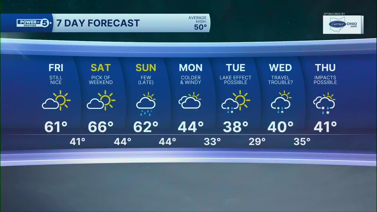
We’re sunny again today with a high around 64. Saturday looks even better with sunshine and a high near 67. We’re not quite talking record warmth, but for late November? This is pretty incredible.
Sunday is still a winner too. We’ll add more clouds later in the day, but highs should make it into the mid 60s.
Then things change in a hurry.
A little light rain is possible Sunday night into early Monday. We’ll start Monday near 50, but don’t expect to stay there. Temps drop into the mid 40s by afternoon as much colder air moves in.
By late Monday into Tuesday, lake effect gets going. A rain/snow mix is possible, but right now this looks like a minor-impact setup, not a big winter storm.
We're watching Wednesday travel CLOSELY
This is the forecast we’ll be watching very closely over the next few days.
An East Coast storm is likely to develop around the busy Thanksgiving travel period. Exactly how close it gets to Northeast Ohio is still uncertain.
The good news? Right now, we’re mainly dry Wednesday.
We’d love to keep it that way.
If you’re traveling Wednesday, though, don’t check the forecast once and forget about it. The exact storm track will matter, and we’ll keep narrowing that down as we get closer.
5-Day Forecast:
Friday: Partly cloudy & mild | High: 64º
Saturday: More clouds & a touch warmer. | High: 67º
Sunday: Sun to clouds. A few evening showers. | High: 64º
Monday: Early shower then windy and colder. Isolated lake effect. | High: 44º
Tuesday: Lake effect rain/snow possible. Windy and cold. | High: 39º
Quick Winter Reminders
- Check your tire pressure: Sudden temperature drops cause tire pressure to dip, which often triggers that pesky dashboard warning light on cold mornings.
- Toss a brush in the trunk: Even though roads will stay wet rather than icy today, overnight lows in the 30s can leave a thin layer of frost on your windshield.
- Dress for the wind, not the thermometer: A 40-degree day feels drastically different when a brisk northwest breeze is blowing off Lake Erie. Wind-resistant layers are your best friend this weekend.
Learn the lingo: The Power of 5 Weather Team wants to get you your forecast closer to home. We have broken NEO into 5 separate and distinct regions. Find your region to get your hyper-local forecast!
- Cleveland Metro Region: Cuyahoga County. This region includes cities such as Cleveland, Parma, Westlake, Berea, Strongsville, Independence, Solon, Beachwood, and Euclid.
- Snowbelt Region: Lake, Geauga, and Ashtabula Counties. This includes cities such as Mentor, Geneva, Ashtabula, Bainbridge, Chardon, Burton, and Orwell.
- Akron-Canton Region: Summit, Stark, and Portage Counties. This region includes cities such as Akron, Canton, Hudson, Ravenna, Mantua, Alliance, and Canal Fulton.
- West Region: Lorain, Medina, Erie, Huron, Richland, and Ashland Counties. This region includes cities such as Lorain, Wellington, Medina, Lodi, Ashland, Mansfield, Willard, and Sandusky.
- South Region: Wayne, Holmes, Tuscarawas, Carroll Counties. This region includes Wooster, Millersburg, New Philadelphia, Strasburg, Mineral City, Carrollton, and Newcomerstown
You can send us photos and short videos by filling out the form below:
Want the latest Power of 5 weather team updates wherever you go? Download the News 5 App free now: Apple|Android
Click here to view our interactive radar.
Follow the News 5 Weather Team:
Trent Magill: Facebook & Twitter
Katie McGraw: Facebook & Twitter
Phil Sakal: Facebook & Twitter
Allan Nosoff: Facebook & Twitter
