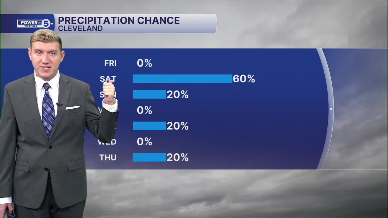


CLEVELAND — It is going to be a wild weekend of weather! Saturday will be very warm, but with a better chance for rain. Meanwhile, Sunday will be much drier but also much colder! Let's discuss...
Overnight will be mild with more clouds in the skies. Clouds act like a blanket over the sky, preventing temperatures from dropping as much. 40s will be common early on Saturday thanks to the clouds. The brief but impressive warm-up happens quickly on Saturday. Highs will be in the 60s as temperatures increase, but winds will be increasing as well, along with rain chances.
It will not be a washout on Saturday. Plan for a couple of sprinkles Saturday morning, with a better chance for storms by the mid to late afternoon and evening. These storms are *most likely* in our southern and eastern communities, especially in communities to the S&E of Akron.
Expect some pockets of heavy rain and gusty winds with the strongest storms, the highest chance being 4 to 8 p.m. There is a slim chance of an isolated strong or severe storm for gusts approaching 60 mph. Storms only look to last a couple of hours and move in and out of the area quickly.
Isolated showers are possible Sunday morning, especially in our easternmost communities, such as in Ashtabula and eastern Lake counties, but most will stay dry on Sunday. However, this is when the chill settles in. The high temperature is expected to happen before the sun goes up on Sunday, with a continued drop through the 40s and eventually the upper 30s by late Sunday afternoon. It will feel like the 30s most of the day Sunday because of the cold wind with gusts occasionally over 30 mph.
It will be a dry and chilly start to the workweek before another storm approaches on Tuesday. This system is coming from the southwest and could brush the southern & western portions of Northeast Ohio with some light rain and wet flakes on Tuesday. Next significant rain chance holds off until late Thursday and Friday of next week.
DAILY FORECAST:
Tonight: Increasing clouds, not as cold. Some mist possible by daybreak. | Low: 45º
Saturday: Warm & windy with afternoon storms.| High: 64º
Sunday: Showers early but drying & cool after. | High: 42º
Monday: Drying out but staying cool. | High: 41º
Tuesday: Mostly cloudy with an isolated chance for showers, especially south. | High: 43º
Want the latest Power of 5 weather team updates wherever you go? Download the News 5 App free now: Apple|Android
Click here to view our interactive radar.
Follow the News 5 Weather Team:
Trent Magill: Facebook & Twitter
Katie McGraw: Facebook & Twitter
Phil Sakal: Facebook & Twitter
Allan Nosoff: Facebook & Twitter
