

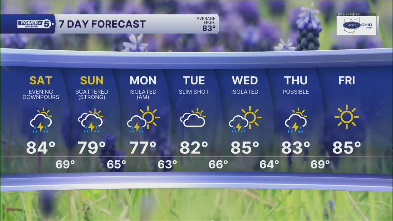


CLEVELAND — Clouds have increased a lot throughout your Friday, along with temperatures and humidity. The clouds are the first sign of changes as a cold front and area of low pressure approach NEO. Over the weekend, rain chances will be increasing as well.
A stray sprinkle is possible late Friday and overnight. A few passing showers will be possible across NEO Saturday morning and afternoon, but they look very light. It's more likely to see rain and storms starting Saturday evening, with heavier rainfall expected overnight and into Sunday. See our Power of 5 Regions forecast below for specific details for your community.
On-and-off downpours and storms will continue throughout the entire day on Sunday. The rain is being brought to you by a slow-moving storm, so the downpours could cause some flooding where they stall out. Areas hit with repeated rounds of rain could also see some flooding. There is also a concern for damaging wind gusts Sunday afternoon and evening. Be sure to have a way to get warnings when you are out and about on Sunday.
The storm will also help temperatures dip a bit on Sunday and Monday. The cool down doesn't last long. In fact, it looks like August will be starting with near-average temperatures and next week is looking fairly unsettled with daily storm chances.
POWER OF 5 REGIONS: Five regions. Five forecasts closer to home.
- CLEVELAND METRO REGION: (Cuyahoga County): Mostly cloudy night with only an isolated shower. Clouds will keep temperatures very mild overnight. Mainly rain-free through at least Saturday morning with only isolated light rain or drizzle. Drenching downpours likely after sunset Saturday into Sunday.
- AKRON-CANTON REGION: (Summit, Stark and Portage Counties): It will be mild & muggy overnight with only a stray shower overnight and into Saturday morning. You will still get plenty of dry time before drenching downpours & storms likely after sunset. On and off storms continue on Sunday.
- SNOWBELT REGION: (Lake, Geauga and Ashtabula): It will be a much cloudier night, but that will keep our temperatures warm. You will notice the sticky air again at the county fair with temps in the mid 80s. Rain stays away until at least Saturday morning, and drenching downpours could wait till late Saturday or even into Sunday wee-hours.
- WEST REGION: (Lorain, Medina, Erie, Huron, Richland and Ashland Counties): Mostly cloudy tonight with a few showers. Isolated and light showers will be possible Saturday morning, with downpours developing later Saturday afternoon and evening.
- SOUTH REGION: (Wayne, Holmes, Tuscarawas and Carroll Counties): Stay cool! Tonight will be noticeably warmer and a few light rain showers Saturday morning. Heavier rain waits til after 3 p.m. Saturday.
DAILY FORECAST:
Friday Night: Mostly cloudy and mild. Stray shower.| Low: 68º
Saturday: Isolated AM drizzle. PM showers and storms, mainly after sunset. | High: 81º
Sunday: A few downpours. Could be strong with elevated flood threat. Humid but cooler. | High: 79°
Monday: Morning leftover downpours. Drying out PM. | High: 83º
Tuesday: Mostly cloudy, warmer. Slim shot of a storm. | High: 86º
Want the latest Power of 5 weather team updates wherever you go? Download the News 5 App free now: Apple|Android
Click here to view our interactive radar.
Follow the News 5 Weather Team:
Trent Magill: Facebook & Twitter
Katie McGraw: Facebook & Twitter
Phil Sakal: Facebook & Twitter
Allan Nosoff: Facebook & Twitter
