


Welcome to April! Northeast Ohio is starting the month on a wintry and cold note. Temperatures are in the 30s with scattered snow. Mother Nature is playing quite the April Fools' joke on us! Or is she?
It is actually not uncommon to see measurable snow in April. On average, Cleveland picks up 2.7 inches of snow during the month of April. In 2005, Cleveland received 19 inches of snow!! That was the most snow ever seen during the month of April, but Cleveland even picked up 8.7 inches of snow last April! So do not be surprised with today's snow or future snow this month!

This list is the top ten snowiest Aprils on Record...
| YEAR | INCHES |
| 2005 | 19.0 |
| 1943 | 14.3 |
| 2007 | 13.4 |
| 1957 | 13.2 |
| 1982 | 13.2 |
| 1996 | 10.2 |
| 2021 | 8.7 |
| 1938 | 8.4 |
| 1952 | 7.8 |
| 2016 | 7.8 |
Note: The snow season starts with any snowfall in the fall of the year prior until snow stops in the following spring.
We have certainly seen plenty of snow this season - especially in January and February. However, we are actually ten inches below average for snowfall in the 2021-2022 season. March 2022 only received 2.5 inches of snow and that was roughly 8 inches below what is typical for March.

What should we expect this April?
More and more daylight! Over the next 31 days, the amount of daylight will increase over one hour! By the end of the month, the sun will not be setting until 8:23 P.M with nearly 14 hours of daylight.

It also looks like the chilly temps could linger. For perspective, temperatures in the 30s are well below average for the first day of April. Typically, high temperatures for early April are in the mid 50s. When we look at the next 6-10 days, the Climate Prediction Center has notable signal for *colder* than average temps. From April 6-10, there is a roughly a 30-40% chance for below normal temps.
It does not look like it will be SHARPLY colder during this time frame and this also does not suggest that there will be zero warm days (for example next Wednesday looks quite warm), but the bulk average seems to fall below normal.

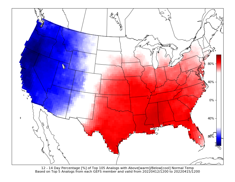
For it is worth, it appears the middle of the month could feature seasonable temperatures to even warmer than normal temperatures. The Cooperative Institute for Precipitation Systems (CIPS) extended analog guidance shows high confidence that 12-14 days out will be warmer than normal. It is shows about a 70% chance for above average temps from April 12-15.
It is likely we will end the month of April with near normal temperatures but with higher precipitation than normal. Keep in mind, monthly forecasts are hard to predict. I am discussing general warming/cooling trends over the next few weeks. It is still best to tune into News 5 to get a check the exact numbers and conditions daily!
Want the latest Power of 5 weather team updates wherever you go? Download the News 5 App free now: Apple|Android
Download the StormShield app for weather alerts on your iOS and Android device: Apple|Android
Click here to view our interactive radar.
Read and watch the latest Power of 5 forecast here.
Follow the News 5 Weather Team:
Mark Johnson: Facebook & Twitter
Remeisha Shade: Facebook & Twitter
