


CLEVELAND — Cold air and lake-effect snow have moved into Northeast Ohio, and an Extreme Cold Warning and Winter Weather Advisory have been issued.
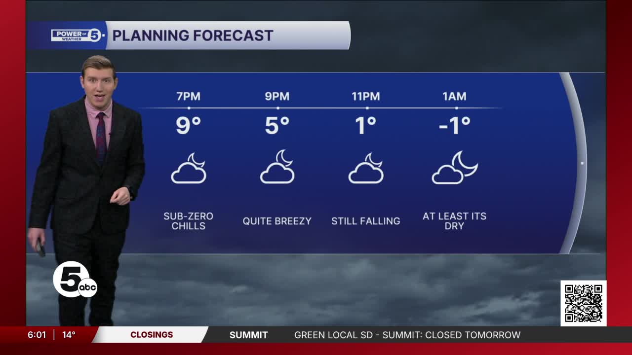
An Extreme Cold Warning has been issued from 7 p.m. Monday through 11 a.m. Tuesday. Wind chills could be as low as 25 degrees below zero.
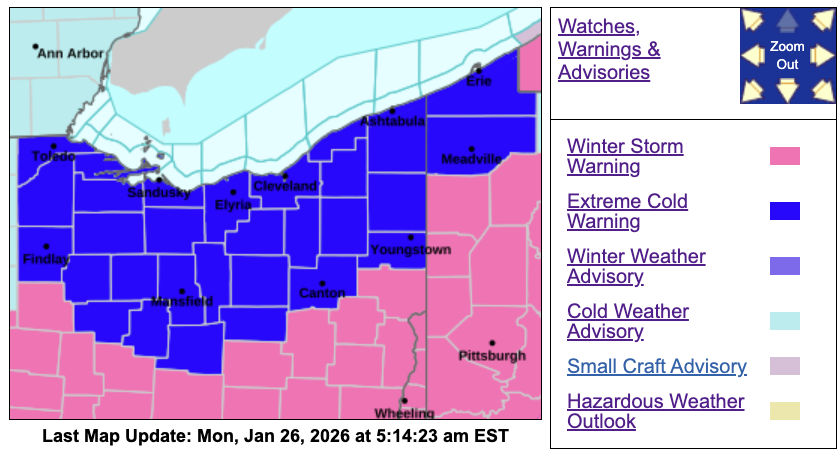
A Winter Weather Advisory is in effect until 8 p.m. in Cuyahoga, Lake, Geauga and Ashtabula counties for lake-effect snow.
Monday afternoon, Allan Nosoff took a look ahead to extreme cold and lake-effect snow
Snow emergencies issued during winter storm
Level 1:
- Medina County
- Portage County
- Sandusky County
- Summit County
- Richland County
Level 2
- Ashland County
- Cuyahoga County
- Erie County
- Huron County
- Ottawa County
- Lorain County
- Wayne County
RELATED: Erie, Huron counties issue Level 3 Snow Emergency

What is a Snow Emergency?
Snow Emergency classifications, according to the Ohio Committee for Severe Weather Awareness:
LEVEL 1: Roadways are hazardous with blowing and drifting snow. Roads may also be icy. Motorists are urged to drive very cautiously.
LEVEL 2: Roadways are hazardous with blowing and drifting snow. Roads may also be very icy. Only those who feel it is necessary to drive should be out on the roads. Contact your employer to see if you should report to work. Motorists should use extreme caution.
LEVEL 3: All roadways are closed to non-emergency personnel. No one should be driving during these conditions unless it is absolutely necessary to travel or a personal emergency exists. All employees should contact their employer to see if they should report to work. Those traveling on the roads may subject themselves to arrest.

Impacts
- Hundreds of schools are closed or delayed on Tuesday. CLICK HERE to see the full list.
- This weekend's winter storm made things difficult for first responders to do their jobs. Freezing temperatures slowed down Chardon firefighters as they battled a barn fire in Claridon Township.
- The City of Akron has announced a 1-day delay for trash pickup. There will be no curbside service on Monday. Trash pickup will resume on Tuesday.
- Summit County Juvenile Court closed on Monday
- Portage County JFS has closed its offices on Monday.
- Most Cuyahoga County buildings will be closed Monday, including the Board of Elections, the Cleveland Municipal Court and the Cuyahoga Common Pleas Court.
- Rumpke Trash & Recycling will be closed on Monday. The company said rubbish/recycling will continue on a 1-day delay for the rest of the week.
- Parma Municipal Court will be closed on Monday.
- The Berea Municipal Court will be closed on Monday. All arraignments originally scheduled for 8:30 a.m. have been rescheduled to Jan. 30 at 8:30 a.m. All other court hearings scheduled at any other time will receive notice of a new date and time to appear, the court said.
- Akron Municipal Court is closed on Monday. The court said interested parties are encouraged to check the Facebook page for more information.
- Shaker Heights will not have trash collection on Monday. Monday’s route will be serviced on Tuesday, Tuesday’s on Wednesday.
- Shaker Heights Municipal Court is closed on Monday.
- City of Warrensville Heights offices are closed on Monday. Set to resume on Tuesday.
- Rocky River Municipal Court will be closed on Monday.
- Lakewood Municipal Court will be closed on Monday.
- Cleveland Heights Municipal Court will be closed on Monday and will reopen on Tuesday.
Salt shortage
A salt shortage is affecting how cities across Northeast Ohio can treat their roads ahead of this weekend's winter storm. More.
WATCH:
RELATED: Communities across Northeast Ohio facing salt shortage
What it looks like out there


You could almost ski on Cleveland's roads on Sunday
WATCH:
Temperatures will remain well below average at least into next week, and Power of 5 meteorologists are tracking a potential Sunday-into-Monday snowstorm.
Watches and Warnings
CLICK HERE to see the list of severe weather watches, warnings, and other weather alerts from the NWS that are currently active in our area.
Power outages
Visit our Power Outage page to find links to see current power outages in Northeast Ohio and to report a power outage.
Traffic impacts
View our News 5 Traffic Map to see any road closures or delays caused by weather or crashes.
Send us photos, videos and reports of the weather
Please stay safe! Do not put yourself in danger to get a photo or video of severe weather. You can email photos and short videos to 5pix@wews.com and email storm reports and information to newsdesk@wews.com.
You can also submit information to us via the form on our Contact Us page here. For files larger than 10 MB, please use a file-sharing service such as Dropbox or WeTransfer.
Want the latest Power of 5 weather team updates wherever you go? Download the News 5 App free now: Apple|Android
Click here to view our interactive radar.
Follow the News 5 Weather Team:
Trent Magill: Facebook & Twitter
Katie McGraw: Facebook & Twitter
Phil Sakal: Facebook & Twitter
Allan Nosoff: Facebook & Twitter
