


Editor's note: CLICK HERE READ THE LATEST UPDATES ABOUT THIS WINTER STORM. The article below will no longer be updated.
Winter Storm Warnings have officially been announced by the National Weather Service ahead of a high-impact winter storm that is expected to bring arctic temperatures, blowing snow in excess of 4 inches and gusty winds up to 60 mph before Christmas.
News 5 Chief Meteorologist Mark Johnson provided a winter weather update Wednesday night:
Watches, Warnings and Advisories
The following counties are under a Winter Storm Warning from 1 a.m. Dec. 23 to 10 a.m. Dec. 24 as well as a wind chill warning until 10 a.m. Dec. 24
- Ashtabula
- Cuyahoga
- Erie
- Geauga
- Huron
- Lake
- Lorain
- Medina
- Portage
- Summit
- Stark
- Ottawa
- Sandusky
- Seneca
- Richland
- Ashland
- Holmes
- Wayne
- Trumbull
Additionally, a wind chill watch and a wind advisory have been issued for Tuscarawas, Coshocton and Carroll counties and will be in effect through Saturday morning.
Head to our Weather Alerts page for the latest alerts from the NWS.
Map of current winter weather alerts:

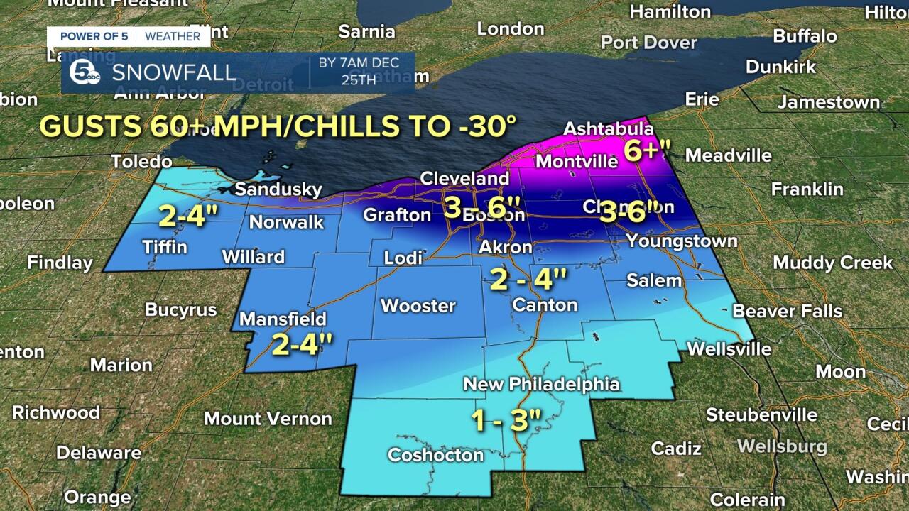
Total snow accumulations in excess of 2 to 6 inches are possible, especially in areas closer to Lake Erie. The northern snowbelt could pick up over 6'' of snow.
Threats and Impacts
With wind gusts as high as 60 mph, wind chill values could be as low as 25 below zero. This could cause frostbite on exposed skin in as little as 30 minutes!
The NWS warns that travel will be difficult to impossible, with areas of blowing snow that could significantly reduce visibility. The hazardous conditions could severely impact the Friday morning commute and holiday travel.
A window of brief intense snowfall is possible with the cold front passing on Friday morning, which will bring a sharp temperature drop over the matter of a few hours, where above-freezing temps Thursday night will drop to single digits by Friday afternoon. A flash freeze is possible with this occurrence and could make it VERY SLICK.
Strong winds could cause tree damage, bring down power lines and blow around unsecured objects.
After Friday, expect lake enhancement snow along the lakeshore to continue through most of Saturday and possibly into Sunday.
Turnpike Bans Some High-Profile Vehicles
The Ohio Turnpike has issued a travel ban effective Friday at 6 a.m. for the entire length of the turnpike for certain high-profile vehicles. The ban is expected to expire Sunday at 8 a.m.

Parking Bans
Have already been implemented in multiple communities. Check your local jurisdiction.
Incoming Storm Timeline
Below is a more detailed timeline of the storm’s impact from the Power of 5 Weather Team:
Rush-hour impact Friday morning
Scattered rain showers are likely Thursday and Thursday night, putting down a layer of liquid on the roads and bridges. A strong arctic cold front will race east through Ohio between 2 a.m. Thursday morning and 8 a.m. Friday morning. Temperatures will fall rapidly from the 40s into the teens during the morning rush hour, causing rapid freezing of any water on untreated surfaces.

Possibly a bit of calm Friday
A brief burst of snow will accompany the cold front early Friday. Winds will also be gusty at 30-40 mph Thursday night and Friday morning. Travel could be difficult due to icy conditions for the Friday morning commute. We will likely then have several hours of dry, cold and windy weather through mid-to-late afternoon Friday. This could allow travelers to hit the road during this brief window. Keep in mind, blizzard-like conditions will be underway Friday across Western Ohio, Northern Indiana, Northern Illinois and Michigan.
The wind picks up Friday afternoon
Wrap-around snow plus 50+ mph wind gusts will arrive by late afternoon or evening Friday across the northern half of our viewing area. Conditions will deteriorate rapidly Friday into Saturday morning with blowing and drifting snow and dangerous wind chills likely most everywhere across Northern Ohio.

When and where to expect snow
Lake-enhanced snow could make travel very tough on I-90 heading east out of Cleveland. As low pressure pulls to the northeast on Saturday morning, most of the snow will end quickly. Lake effect snow will likely set up across the primary snowbelt with continued snow accumulations across Lake, Geauga and Ashtabula counties through Sunday where squalls persist. Elsewhere, windy cold weather remains with highs in the single digits and lower teens thru Christmas Day and wind chills to -15 degrees.

What we’re confident about
1) ARCTIC COLD with a Rapid temperature drop and a flash freeze Friday morning.
2) VERY HIGH WINDS gusting above 50 mph at times creating wind chills well below zero thru Christmas Day.
What we’re still unsure of
1) POSITION OF THE LOW PRESSURE. A strong bomb cyclone over Lake Erie would be much worse for us than a strong storm over Southern Ontario.
2) SNOWFALL TOTALS. Several inches of snow are possible for all of us across Northern Ohio by midday Christmas Day with areas of the snowbelt east of Cleveland likely to see the heaviest accumulations.
The Power of 5 Team is expected to be able to provide snowfall estimates for our area by Wednesday.
Prepare NOW!
Make sure you have an emergency kit and a plan. Power company officials say to have flashlights, extra batteries, first aid kits, radios and non-perishable foods ready, and ensure your devices are fully charged.
RELATED: Power companies prepping for potentially severe winter storm system ahead of the holidays
If you are planning to travel for the holidays, consider changing those plans.
For those who plan to commute regardless of the weather, AAA recommends taking some precautions, including making sure your car is in working order, including windshield wiper blades, wiper fluid suited for winter and safe tires with good traction.
Experts say motorists should also have an emergency kit in their cars, tailored for winter weather:
- Start with things to keep you warm in case you become stranded. Items like blankets, gloves and hats.
- Then, make sure to have non-perishable food items—granola bars, trail mix, crackers, jerky and of course water.
- Making sure to have items to help if you get stuck, like a shovel, sand or kitty litter, is also important.
- And of course, the typical road care kit—making sure you have jumper cables, a flashlight and a first aid kit.
RELATED: With winter weather in Northeast Ohio's holiday forecast, motorists advised to plan ahead
Radar
View the current Power of 5 Weather Team radar below:
Power outages
Visit our Power Outage page to find links to see current power outages in Northeast Ohio and to report a power outage.
Traffic impacts
View our News 5 Traffic Map to see any road closures or delays due to the weather or crashes from the weather.
Send us photos, videos and reports of the weather
Please stay safe — do not put yourself in danger to get a photo or video of severe weather. You can email photos and short videos to pics@wews.com — please include the time, date and location — and email storm reports and information to newsdesk@wews.com.
You can also submit information to us via the form on our Contact Us page here. For files larger than 10MB, please utilize a file-sharing service like DropBox or WeTransfer.
Want the latest Power of 5 weather team updates wherever you go? Download the News 5 App free now: Apple|Android
Download the StormShield app for weather alerts on your iOS and Android device: Apple|Android
Click here to view our interactive radar.
Read and watch the latest Power of 5 forecast here.
Follow the News 5 Weather Team:
Mark Johnson: Facebook & Twitter
Trent Magill: Facebook & Twitter
