


CLEVELAND — It is the big talk across Northeast Ohio...are you ready for the FIRST SNOW of the season?! We are still a couple of days out, but the entire Power of 5 weather team is keeping a super close watch on the forecast for this weekend and early next week. Let's pump the brakes, though... before that happens, let's talk about the rest of your Friday and Saturday.
Rain and storms swiftly pushed through NEO this morning and afternoon and are exiting to the east. It was all in and out very quickly. If you have Friday evening plans, it looks dry. Saturday will be fairly quiet. Only a couple of light showers are possible. Enjoy it, because heavier, widespread rain rolls back in overnight and into Sunday. That's when things REALLY change.
Sunday's rain is a CHILLY rain. It will get started early, too. Temps will be in the low 50s and upper 40s to start the day, but will be dropping and dropping into the 30s by the afternoon/evening. As temperatures fall, rain will change to snow by Sunday evening, but accumulation will be tough at that point. The warm, wet ground will make it tough for anything to stick...at first.
Temps keep dropping late Sunday into early Monday. As soon as we hit the lower 30s, we'll start to see accumulations start on elevated and grassy surfaces. Bridges and overpasses will be impacted first. As winds shift more northerly, we'll have to watch lake effect snow squalls set up. Timing is critical for how much snow we'll see. It's all about how soon those winds align and how long it takes to shift westerly.
Still a little too early to talk numbers, but a few inches of wet snow accumulation is looking more and more likely, especially in the snowbelts. Roads will be slick while it's snowing. Make sure you're prepared for our first wintry day on Monday.
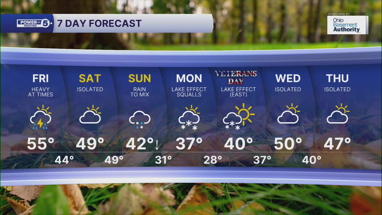
DAILY FORECAST:
Friday Night: Drier, calmer winds, and cool. | Low: 44º
Saturday: Looking mainly dry. A couple of showers north. | High: 49º
Sunday: Widespread rain likely. Changing to snow as temps fall. | High: 49º (30s by Sunday evening)
Monday: Lake effect snow squalls. | High: 37º
Tuesday: Lake effect snow. | High: 40º
Want the latest Power of 5 weather team updates wherever you go? Download the News 5 App free now: Apple|Android
Click here to view our interactive radar.
Follow the News 5 Weather Team:
Trent Magill: Facebook & Twitter
Katie McGraw: Facebook & Twitter
Phil Sakal: Facebook & Twitter
Allan Nosoff: Facebook & Twitter
