


BROOK PARK, Ohio — Marge Wichert remembers freezing at the old Cleveland Municipal Stadium during Browns games with her husband, who was a die-hard fan.
“The wind chill is minus 10 or 15, and he still wouldn’t leave,” she said.
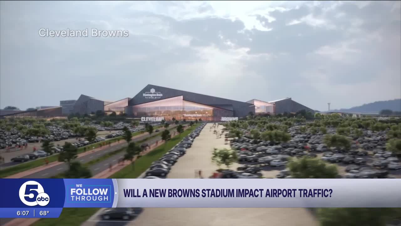
So Wichert can see why the team wants to replace its current, open-air stadium on the Downtown lakefront with an enclosed one in Brook Park. She’s just not sure what it will mean to have that stadium built less than half a mile from her house.
“It’s gonna be a lot of construction, on and off,” said Wichert, who has lived on the same quiet street in Brook Park since 1978.
She’s worried about construction activity, noise and game-day crowds.
“The more traffic you can get from the freeway directly into it, the better,” she said of the proposed stadium and entertainment district, on 176 acres off Engle and Snow roads, just west of Interstate 71.

A draft feasibility study filed with the Ohio Department of Transportation this month includes more details about plans for access to the site – and possible traffic snarls on big event days. The 1,600-plus-page report was prepared by Osborn Engineering, a consultant working for Browns owner Haslam Sports Group.
The consultants concluded that NFL games and major events won’t cause backups on State Route 237, which travelers use to get to and from Cleveland Hopkins International Airport. But there’s potential for some slowdowns on Interstate 480 on weekdays.
“We don’t forecast heavy congestion on 237 or on 71 during event day traffic. We do expect there will be some areas of congestion in outlying areas,” Dennis Albrecht, Osborn’s director of transportation, said during an interview Monday afternoon. “And we’ll work … to develop traffic management plans for those event days.”
Maps included in the feasibility study identify potential pinch points.
On Sundays and weeknights, there could be heavy traffic on Bagley and Engle roads in Middleburg Heights, the consultants found. Bagley is the next entrance and exit point on I-71 to the south of the proposed stadium district.

On weekdays, during NFL games or concerts, drivers could face delays at several other intersections – along Smith Road, West 150th Street and Brookpark Road.
Sunday slowdowns will be less severe, according to the study.

“We’ve been collaborating with the city of Brook Park and their safety services – fire and police – and determining what roads they know already are congested and what roads they anticipate being congested for the events,” Albrecht said, adding that game-day plans for managing traffic are still in the works.
The study shows temporary road closures on Hummel and Engle roads leading into the site. Drivers must cross busy railroad tracks at both locations.
“We are working to avoid any type of traffic crossing railroad tracks. … We want to keep it safe. We don’t want any cars on railroad tracks,” Albrecht said.
The study also mentions posting police at key intersections, developing efficient ways for people to park and adding clear signs so people can get where they’re going.
“A traffic control center operated by the city of Brook Park is being considered for purposes of monitoring traffic flows, adjusting traffic signal timing, locating route blockage due to crashes or breakdowns and the use of variable or changeable message signs,” the consultants wrote.
A site plan for the stadium district shows the main entrance will be located off Engle, across from a company called Mr. Formal Transportation and an airport parking lot. But Albrecht said that’s unlikely to be the main entrance to the site on game days, or when huge concerts are in town.

Instead, the Browns are looking at having drivers enter and exit large parking lots off of Snow Road, near one edge of the site, and further north on Engle.
'A much safer option'
The city and Haslam Sports Group are also planning long-term changes to the roads around the site. The feasibility study provides more detail about those plans, which the city outlined in an application for $70.3 million in state funding earlier this year.

Drawings show a wider exit ramp off I-71 northbound to Snow Road, with two left-turn lanes. The I-71 southbound exit would change more dramatically, leading to a flyover ramp that would carry cars over Engle and CSX railroad tracks, before touching down on a ring road right next to the stadium site.
“Currently, there’s no way to get to this site except by going across railroad tracks,” Albrecht said. “So we’re taking that out, and we’re putting in a much safer operation.”
The plans also call for streamlining the tangle of streets around the stadium site, a former Ford Motor Co. manufacturing property where thousands of people once worked. Some of those one-way streets will disappear, to be replaced by fewer, wider roads.
“The mayor has affectionately called it the spaghetti bowl of roads,” Albrecht said, pointing to a map. “So we’re removing the spaghetti network out there. We’re putting in a much more simplified roadway network.”
Existing businesses and property owners along Snow and Engle roads won’t lose their access, he said. And the roadwork won’t spill over onto any private property.
“That’s an important thing,” he said. “Throughout this project, we avoided taking any private property at all. This is all built on existing public land.”
The city and private investors are in negotiations about buying land northeast of the stadium site for parking lots. Mayor Edward Orcutt alluded to those conversations during a public meeting Friday, saying a potential acquisition of a very large property is in the works.
RELATED: With aviation fight settled, Browns stadium talks turn back to roads, parking
The draft feasibility study confirms that there will be 12,000 parking spaces on the stadium property – and a potential need for 10,000 more. City officials want to see parking along Engle, Brookpark Road and West 164th Street, in what's now a largely industrial area.
RELATED: Report says Browns will be short 10,000 parking spots on game days in Brook Park
Osborn’s drawings show a pedestrian path from West 164th down to Hummel, with a bridge stretching over Engle to the stadium site. One end of that bridge would sit on land that’s occupied by a concrete plant now.
“Haslam Sports Group and the city are talking with … the owners of that site and determining what we’re gonna do,” Albrecht said. “We can move the bridge. There’s other areas to move it to. And we’ll work with whatever property owner is willing to work with us.”
The owner of the concrete plant has not responded to inquiries from News 5.
The most recent public infrastructure designs for the area also show a new Greater Cleveland Regional Transit Authority Rapid station, next to an RTA service yard just west of the stadium site. The transit agency has said it won’t pay to add a new stadium when there are existing stations nearby at Hopkins and on Brookpark Road.
During a meeting at the Northeast Ohio Areawide Coordinating Agency on Friday, a NOACA staff member said the estimated cost of that station is $40 million, at this point.
“We’re talking with the RTA on a regular basis,” Albrect said. “We have meetings with them every two weeks. They have mentioned that they don’t have any funding available. We understand that, but we appreciate their collaboration as we continue to work to develop a potential new RTA station.”
He said Haslam Sports Group’s engineering and traffic consultants have also talked to leaders at Hopkins. Cleveland’s top airport official has expressed concerns about having an NFL stadium so close by. Citing the project’s height, the airport unsuccessfully fought to keep ODOT’s aviation office from approving a permit for the project.
ODOT issued that permit last week, after weeks of negotiations with Haslam Sports Group and its aviation consultants.
RELATED: ODOT approves Browns' Brook Park stadium plans, ending dispute over airspace
“We work closely with the airport,” Albrecht said, acknowledging that Hopkins is launching a major modernization effort that involves adding and demolishing buildings.
“We’ve sat down at this very table and collaborated on all of these traffic issues,” he added, gesturing across a large conference room at Osborn’s offices. “We gathered all the information from the airport traffic consultants. We incorporated that into our data and our analysis, and the roads are built based on that data.”
The changes are still being evaluated by NOACA, a metropolitan planning agency that has a multi-step process for vetting and adopting projects. A decision on Brook Park’s request for $70.3 million in state funding, through the Transportation Review Advisory Council, won’t come until next year.
ODOT and Brook Park plan to hold a public meeting about the infrastructure work on Oct. 28, according to the feasibility study. An announcement and advertisements about the meeting are scheduled to go out later this month.
From her nearby residential street, Wichert is watching. She’s been a regular fixture at Brook Park City Council meetings. And she’s been sharing her concerns with the mayor.
“I trust the mayor,” she said. “He’s very open. He’s above-board.”
But she’s still worried about changes – all the unknowns.
“So we’ll see what happens, going forward. And whether I’m still around when it’s done,” she said, with a laugh.