


CLEVELAND — It will stay in the upper 20s to near-30 tonight. A few snow showers will be possible, especially in our southern communities. Accumulations will be under 3 inches.
Saturday morning into the early afternoon, temperatures will be around 32°. Temps drop again Saturday afternoon into Saturday night. As yet another clipper during your Saturday, especially in the morning and midday moves through. A few snow showers could drop an additional inch or two, especially south and east of I-77. Temperatures will fall into the 20s and Teens through the end of Saturday afternoon into the evening. Wind Chills will be in the Single Digits and even below zero by the end of the day on Saturday
Colder air settles in on Sunday, with highs in the mid to upper Teens, under mostly cloudy skies. An isolated flake will be possible, but most of the region look to be dry. Wind chills will be into the Single Digits and Below Zero for the second half of the weekend.
Guess what? More snow is on the way for the start of next week. The pattern is holding strong for a few more weeks. Several clippers will keep an active pattern MLK Day through the middle of next week. Between the storms, one major surge of Arctic Air will send the coldest air of the season so far into Monday night into Tuesday. Temperatures might not even get out of the single digits with sub-zero lows and wind chills approaching 20 below zero!
Stay Warm and Safe, Northeast Ohio!
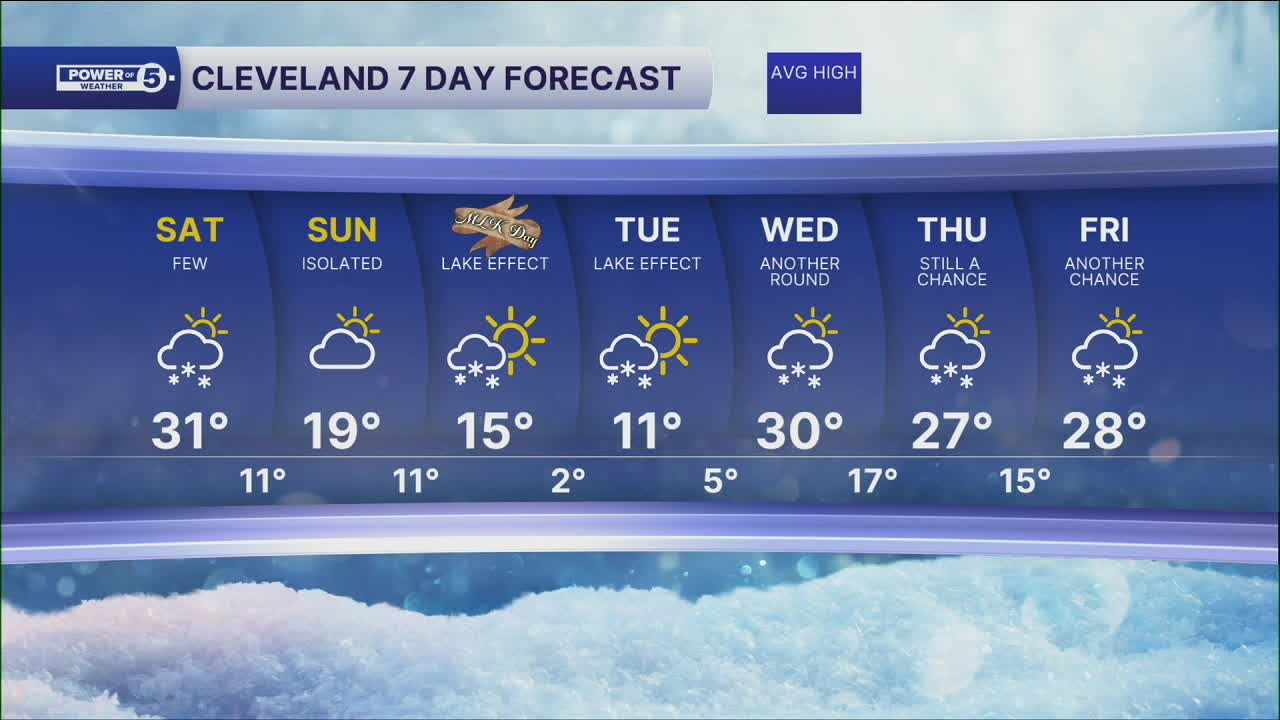
DAILY FORECAST:
Saturday: Few snow showers possible. PM Falling temps. | High: 31º
Sunday: Isolated snow possible. Frigid. | High: 19º
MLK Day: Scattered snow possible. Frigid. | High: 15º
Tuesday: Lake effect snow possible. Frigid. | High: 11º
Wednesday: Snow possible. Warmer. | High: 30º
Thursday: Still a chance of snow showers. | High: 27º
Thursday: Another chance of snow showers. | High: 28º
Want the latest Power of 5 weather team updates wherever you go? Download the News 5 App free now: Apple|Android
Click here to view our interactive radar.
Follow the News 5 Weather Team:
Trent Magill: Facebook & Twitter
Katie McGraw: Facebook & Twitter
Phil Sakal: Facebook & Twitter
Allan Nosoff: Facebook & Twitter
