


CLEVELAND — It is the big talk across Northeast Ohio...are you ready for the FIRST SNOW of the season?! We are still a couple of days out, but the entire Power of 5 weather team is keeping a super close watch on the forecast for this weekend and early next week. But before that happens, we will also be dealing with a wet and windy Friday!
After a quiet and nice day, the clouds are coming back, and the wind picks up overnight. Friday starts with gusts to 30 mph, with peak winds midday reaching 40 to 45 mph. This is thanks to a cold front that will also bring rain our way.
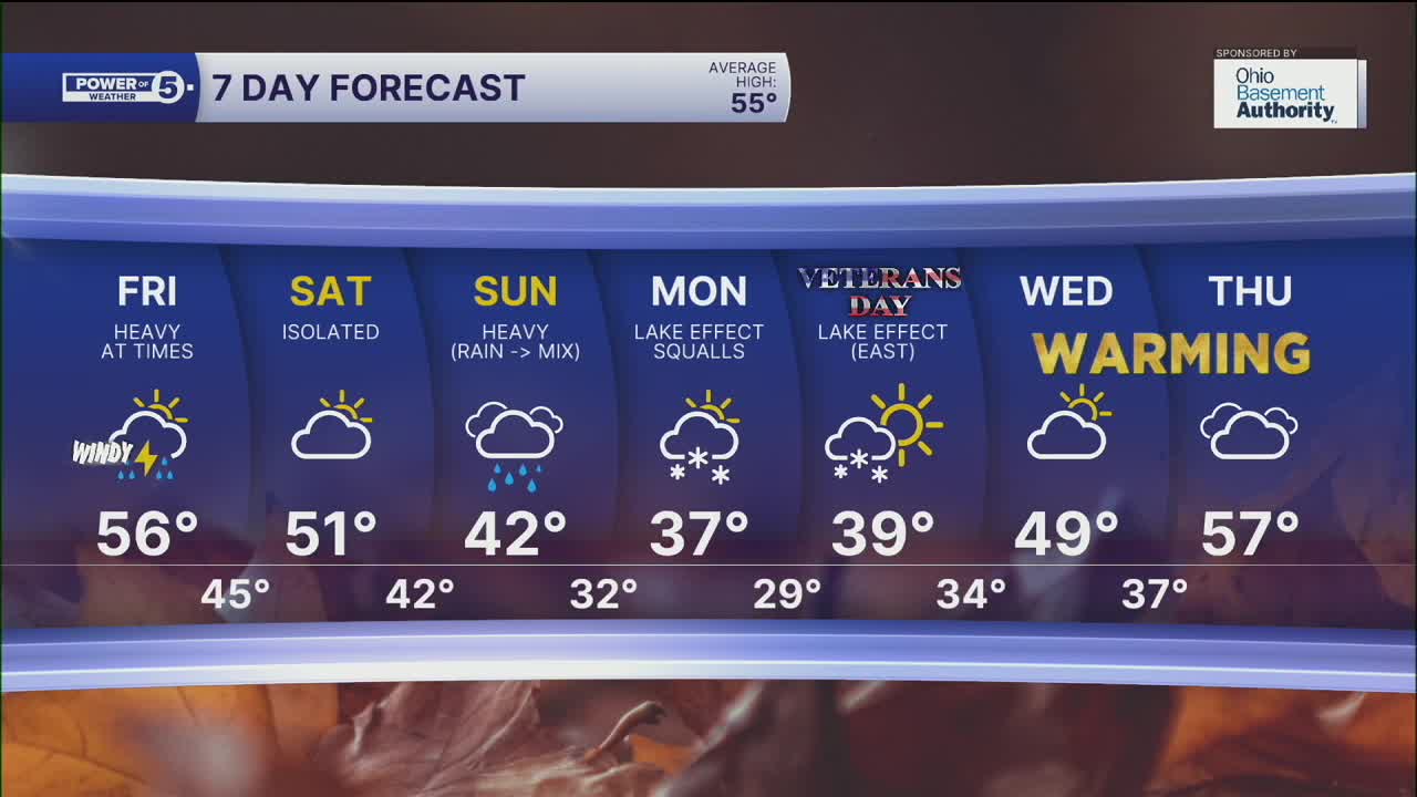
Rain arrives from the northwest around 9 a.m. and exits to the southeast around 4 p.m., which means most of the daylight hours will be wet & windy. Rain could be heavy at times. Most communities across NEO will pick up a range of 0.10 - 0.50 inches of rain.
It's all in and out quickly. If you have Friday evening plans, it looks dry. Saturday will be fairly quiet with a mix of sun and clouds, and only a couple of showers are possible. Enjoy it because the rain rolls back in on Sunday. That's when things REALLY change.
Sunday's rain is a CHILLY rain. Temps will be in the 40s and dropping. It will be in the 30s heading into Sunday evening, watching any raindrops change to snowflakes. Looks like the best shot for snow will start Monday morning as lake effect snow takes over.
Snow is likely early next week, but it will not be for everyone, and totals will vary. There will be impacts for everyone, snow or not, as it will be the coldest air in a long time, too. It is still quite early for specifics, including the "3 T's," which are track, timing, and totals. For more on that and the logistics of winter forecasting, check out Allan's detailed look inside that world by clicking this link.
DAILY FORECAST:
Thursday night: Chilly. Increasing winds and clouds.| High: 52º
Friday: Soaked with heavy rain possible from 9 am to 5 pm. Windy. | High: 57º
Saturday: Looking mainly dry. | High: 50º
Sunday: Mainly rain but much cooler. A wet flake late. | High: 42º
Monday: Lake effect snow squalls. | High: 37º
Want the latest Power of 5 weather team updates wherever you go? Download the News 5 App free now: Apple|Android
Click here to view our interactive radar.
Follow the News 5 Weather Team:
Trent Magill: Facebook & Twitter
Katie McGraw: Facebook & Twitter
Phil Sakal: Facebook & Twitter
Allan Nosoff: Facebook & Twitter
