



CLEVELAND —
Soaking start Friday as temperatures crash.
Widespread rain has moved in this morning, with the Friday morning commute being impacted by ponding on roads and localized flooding. Have extra time built into your morning plans.
The rain tapers off from northwest to southeast later Friday morning, and we'll dry out during the afternoon. The highest rainfall amounts will be around 0.75 to 1 inch mainly in the West, Cleveland Metro and Snowbelt regions, with smaller totals in our South region.
Power of 5 Regional Highlight: West Region
The first in line for the rain, and the longest duration of rain is expected here too. While the heaviest downpours are most likely to depart by sunrise, rain will continue through midday.Reduced visibility, standing water, and an impacted Friday morning drive will be things to keep in mind.
"Fall"ing Temperatures:
Temperatures just took a BIG hit this morning. It was 78 degrees at Burke Lakefront in Cleveland before the rain began, and temps dropped 15 degrees in about an hour. We'll spend much of the day in the lower 60s. Friday night football will feel much different than recent weeks. Temperatures fall back into the 50s with a clearing sky developing Friday evening, with lows in the 40s for much of NEO.
The weekend looks and feels much more like October. As the baseball saying 'fall classic,' it will be classic fall weather. Highs stay in the 60s, while mornings start in the 40s. If you've been waiting for sweater weather, it's here. Grab the fall jackets because the cooler pattern sticks around through the first half of next week.
5-Day Forecast:
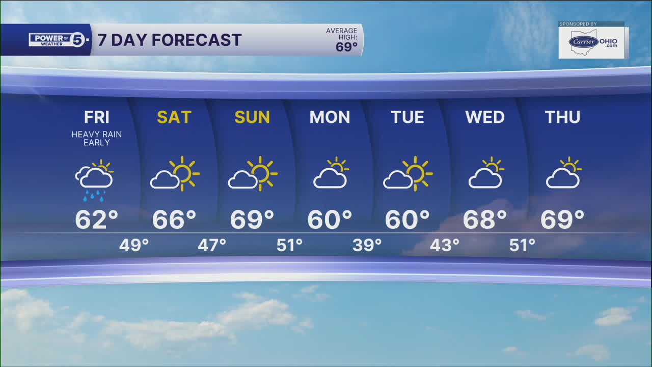
Friday: Morning downpours. Clearing late. Colder. | Noon temp: 62º
Saturday: Drying and clearing, cool and comfy. | High: 66º
Sunday: Bright but cool. | High: 69º
Monday: Cold front passes with some clouds. Cooler. | High: 59º
Tuesday: First frost of season inland. Sunny and cool. | High: 60º
Learn the lingo: The Power of 5 Weather Team wants to get you your forecast closer to home. We have broken NEO into 5 separate and distinct regions. Find your region to get your hyper-local forecast!
- Cleveland Metro Region: Cuyahoga County. This region includes cities such as Cleveland, Parma, Westlake, Berea, Strongsville, Independence, Solon, Beachwood, and Euclid.
- Snowbelt Region: Lake, Geauga, and Ashtabula Counties. This includes cities such as Mentor, Geneva, Ashtabula, Bainbridge, Chardon, Burton, and Orwell.
- Akron-Canton Region: Summit, Stark, and Portage Counties. This region includes cities such as Akron, Canton, Hudson, Ravenna, Mantua, Alliance, and Canal Fulton.
- West Region: Lorain, Medina, Erie, Huron, Richland, and Ashland Counties. This region includes cities such as Lorain, Wellington, Medina, Lodi, Ashland, Mansfield, Willard, and Sandusky.
- South Region: Wayne, Holmes, Tuscarawas, Carroll Counties. This region includes Wooster, Millersburg, New Philadelphia, Strasburg, Mineral City, Carrollton, and Newcomerstown
You can send us photos and short videos by filling out the form below:
Want the latest Power of 5 weather team updates wherever you go? Download the News 5 App free now: Apple|Android
Click here to view our interactive radar.
Follow the News 5 Weather Team:
Trent Magill: Facebook & Twitter
Katie McGraw: Facebook & Twitter
Phil Sakal: Facebook & Twitter
Allan Nosoff: Facebook & Twitter
