


CLEVELAND — Wednesday kicks off the start of a major winter storm arriving in Northeast Ohio. The highest impacts will be felt Wednesday through early Friday with periods of heavy rain, sleet, freezing rain and snow all on the table, along with ice.
Power of 5 Chief Meteorologist Mark Johnson provides an update as the major winter storm begins to take shape. Watch the video in the player below:
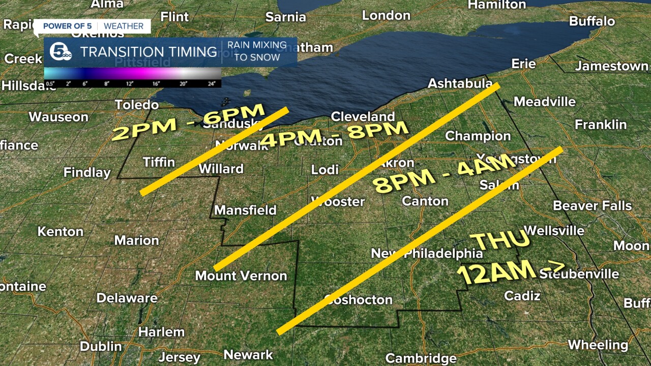
The timing: When does it transition from rain to ice then snow?
Rain has turned to snow for the Lakeshore counties including Greater Cleveland, with snowfall totals of 4 to 6 inches of snow by the morning rush Thursday.
Rain continues south of the shoreline counties through the evening. The rain to our south in Akron, Canton, Ravenna and surrounding areas could be heavy at times with a half of an inch to 1 inch of rain potentially before it transitions to sleet and snow. That transition from rain to sleet and snow will continue overnight from northwest to southeast. Areas from Youngstown to Canton to Millersburg may not transition to snow until sometime Thursday morning. There may be a break in the sleet and snow for a few hours Thursday morning as we await the next round.
RELATED: Ohio Turnpike bans high-profile vehicles Wed. through Friday during expected winter storm
By early Thursday afternoon, the air should be cold enough for all snow across most of Northern Ohio. Snow, heavy at times, will likely be the dominant precipitation from Thursday afternoon and evening with significant accumulations of 8 to 12 inches of total snow possible from the south shore of Lake Erie to as far south as Youngstown to near Canton and Mansfield through Friday 7 a.m. The snow should end from northwest to southeast beginning Thursday evening into the early hours of Friday morning.
How much snow?
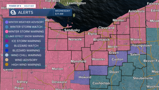
The National Weather Service has included more counties under a Winter Storm Warning that is in effect from 10 p.m. Wednesday through Friday at 7 a.m.
The Winter Storm Warning is in effect for Ashland, Ashtabula, Cuyahoga, Erie, Geauga, Huron, Lake, Lorain, Medina, Richland, Summit and Wayne counties.
The Power of 5 meteorologists are expecting up to 12" for a majority of Northern Ohio with lower numbers south. The lack of snow will be due to an increase in ice. So try not to focus too much on snow totals; the impacts are widespread.

The uncertainty
The big question mark remains: Where will the heavy snow end and the sleet begin? Snow totals will be cut where the sleet dominates. The latest computer guidance is in reasonable agreement Wednesday that the snow/sleet line will set up somewhere between Canton and New Philadelphia. That means snow would be the primary issue in our northern counties. Sleet would at least compete with the snow through parts of Thursday morning in those southern Winter Weather Advisory counties.
The impacts
Snow and sleet and a small amount of freezing rain are expected area-wide overnight into Thursday morning as temperatures drop below freezing. Where heavy rain has fallen, we'll see a lot of those wet surfaces freeze up by Thursday mid-morning. Drive with care. Moderate to heavy snow closer to Lake Erie tonight will create snow-covered and slick roads for morning travelers. Sleet and snow father south will create similar issues on the roads. Snow will pick up in intensity again Thursday afternoon all across Northern Ohio creating slow and slick road conditions everywhere for afternoon and evening travel. Lighter snows are expected Thursday night into Friday morning, especially for areas south of Youngstown and Akron as the storm pulls away. Lingering travel impacts can be expected Friday morning due to the heavy snow accumulations from Thursday.
School Closures
See an updated list of schools, districts and other organizations that are closed due to the weather here.
Snowplow Tracker
The City of Cleveland now has an online snowplow tracker map, allowing you to view the progress of the city's plows in real-time.
Click here to learn more about it and see the map.
Snow Emergency Levels
Erie and Huron counties have issued a level two snow emergency level. More here.
How to stay informed
Remember to keep checking back with News 5 for the latest updates on the forecast, including additional watches and warnings. Our meteorologists will bring continuous coverage during Good Morning Cleveland, News 5 at Noon, News 5 at 4, News 5 at 5, News 5 at 6, and News 5 at 11 all week long. Severe weather alerts, including updates on road closures, power outages and school closings, are available on the News 5 app.
Want the latest Power of 5 weather team updates wherever you go? Download the News 5 App free now: Apple|Android
Download the StormShield app for weather alerts on your iOS and Android device: Apple|Android
Click here to view our interactive radar.
Read and watch the latest Power of 5 forecast here.
Follow the News 5 Weather Team:
Mark Johnson: Facebook & Twitter
Remeisha Shade: Facebook & Twitter
